


|
||

|

|
|

|
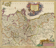
Decorative section from Eilhard Lubin's remarkable map of Pomerania, first published in 1618.
The map shows the region centered on Bytow in Poland with views of the following cities:
- Belgardt (Bialogard)
- Treptow (Trzebiatów)
- Piritz (Pyrzyce)
- Golnow (Goleniow)
- Wollin oder Iulina (Wolin)
As noted on the David Rumsey website:
Large and impressive outline colored copperplate engraving map of Pomerania on 12 sheets, 42 x 54 cm or smaller, by Eilhard Lubin, Professor at the University of Rostock. In 1610 he was asked by Philipp II, the Duke of Pomerania to create a large scale map of the geography and history of the duchy. In 1612 map was completed, it was decorated with 49 town views, and coat of arms of the noble families. In 1618 the Dutch engraver Nicolas van Geelkercken, engraved the copperplates in Amsterdam, and a small number of sheets were printed. The plates disappeared in the thirty years war and were rediscovered by the historian Johann Carl Conard Oelrichs in 1758. The map shows 49 town views on the border, the family tree of the house of Griffins, dukes of Pomerania, with 157 names and small portraits, a small family tree of the house of Rugen, 5 large portraits of living dukes of different parts of Pomerania, and on the lower middle left sheet probably the portrait of Lubin himself. The map shows towns and villages, landmarks, churches, forest, rivers and mountains. Relief is shown pictorially. Lubin's Pomerania remained the most accurate map of the region from its inception in 1618 until the Prussian topographical survey of the eighteenth century. The map is extraordinary in the way that it combines the "mapping" of the history of the ruling families with the mapping of the topography of Pomerania.
Nicholas (sometimes Nicolaes, Nicolaas, or Nicolas) van Geelkercken (sometimes Geelkerken, or Geilekerck) (fl. 1600-1656) a Dutch cartographer from the 17th century, isn’t as prominently recognized as some of his peers. However, his contributions to the field are noteworthy and deserve attention. There's some debate over his birthplace; Waller suggests Scherpenzeel in Guelders, Hollstein posits Zutphen, and some even point to Geilenkirchen in Germany due to the similarity in name.
The first known record of Geelkerken’s work dates back to 1600, with a depiction of the Castle of Verwolde. Then, a decade-long gap ensues until 1610, when records show his various roles as a draughtsman, engraver, publisher, and surveyor. Initially, he lived in Leiden, briefly in Amsterdam around 1615 and 1616, and later moved to Arnhem after his appointment as the surveyor of Guelders. He passed away on September 25, 1656, and was succeeded by his son Isaak.
In 1610, Geelkerken produced a map of the world titled Universi Orbis Tabula De integro Delineata. This map, printed in Amsterdam, measured 41 by 56 cm and featured allegorical images of the then-known parts of the world. Notably, it showcased the voyages of notable explorers such as Magelhaen, Candish, Drake, and Van Noort.
By 1616, Geelkerken released another world map published by Johannes Janssonius. Although the first edition of this map hasn't been found, later editions from 1618 are available. This map, too, had details about famous explorers, and notably lacked updates about the discoveries of Schouten and Lemaire.
In 1619, Geelkerken published Oost ende West-Indische Spiegel, which detailed the voyages of Joris van Spilbergen and Schouten and Lemaire. Within this work was a world map, which later influenced the works of other cartographers.
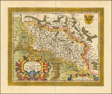
One of Geelkerken's projects was also engraving for a map of Pomerania by Eilhard Lubin, which spanned 12 sheets and was quite detailed. Similarly, Geelkerken was involved in creating a map of Palestine in collaboration with his brother Arnoldus Geilkerkius, who had traveled to Palestine.
Apart from these, Geelkerken made significant contributions to the mapping of Friesland. In Ubbo Emmius' De Frisia et Frisiorum Republica, Geelkerken presented detailed plans of the Frisian towns. Furthermore, his map of Frisia, created in 1618, provided a comprehensive view of the region during that time.
Geelkerken’s work also included a 1621 map of Rhaetia and his participation in Phil. Cluverius' Italia antiqua in 1624. His dedication to the field was evident in the numerous war-maps and historical prints he engraved, particularly those related to the Julierswar of the early 1610s.
In summary, while Nicolaas Geelkerken might not be the most celebrated cartographer, his dedication to his craft and the multitude of maps he contributed to reflect his essential role in the cartography of the 17th century.
![(Second World War - Holocaust) Hitlerowskie wiezienia i areszty na ziemiach Polskich w latach 1939-1945 | Hitlerowskie obozy pracy na ziemiach Polskich w latach 1939-1945 [Nazi prisons and arrests in Poland in 1939-1945 | Nazi labor camps in Poland in 1939-1945]](https://storage.googleapis.com/raremaps/img/small/82908.jpg)
![[ Tribal Germany ] Germania Antiqua in IV magnos populaos in minores et minimos distincta et Regiones Danubium…1785](https://storage.googleapis.com/raremaps/img/small/97958.jpg)