|
||

|

|
|

|
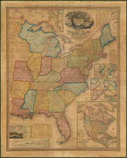
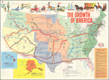
An Unrecorded State of This Important International Collaboration Promoting The Transcontinental Railroad
Previously unrecorded 1868 edition of Haasis & Lubrecht's scarce decorative map of the United States, published for the American and German Emigrant Markets.
The map was published to exploit interest in America the prospective transcontinental railroads which were then under construction.
Striking and highly detailed coast to coast map of the United States, with an elegant title and vignette featuring Lady Liberty riding an eagle and clutching the American flag.
The map shows the proposed route of the North Pacific Railroad in blue and the Central Pacific in red. Additional routes are also shown in blue, including the route of the Atchison, Topeka and Santa Fe Railroad and two lines within Califronia. These routes would be dramatically revised with later editions.
The map is a revised version of the Lubrecht and Rosa map "The American Continent" of 1864, which lacked the decorative elements of this map and included 2 less text tables and did not include the seal of the US and the Coat of Arms of the US in the waters of the Gulf of Mexico. Population tables of the United States are added to the left and right sides of the map. The map itself has been updated to show political and some topographical changes of the ensuing seven years. Projected railroad lines are shown running everywhere in the west.
Perhaps the most noteworthy change in this state of the map is the addition of the route of the proposed Northern Pacific Railroad, which is not included in the 1864 or 1865 editions of the map. The early editions included only a single proposed route for the Central Pacific Railroad and the Southern Pacific Railroad. By contrast, the present map adds multiple lines in California, the route of the AT&SF and several additional lines through Nebraska, Kansas, Colorado, Wyoming, Utah, Nevada, Arizona and Oregon.
Between 1871 and 1874, the map was updated to show the new railroad lines which were being actively developed in the US. Describing the 1871 edition, Rumsey notes:
The map itself has been updated to show political and some topographical changes of the ensuing seven years. Projected railroad lines are shown running everywhere in the west. The coloring is very bright, to match the decidedly optimistic (expansionist) flavor of the map. D.L. Guernsey published editions of 1871 and 1874 in Concord New Hampshire, with no major changes in the map. . . .Issued in a cover with a label in German from Wilhelm Lubrecht in Stuttgart, Germany, indicating it may have been sold to emigrants.
Rarity
The early editions of the map are quite rare. Rumsey notes editions in 1864 (one example located -- Rumsey Collection), 1865 (one example located -- British Library) and 1869 (4 copies located). This 1868 edition seems to be unrecorded.
Provenance
Purchased from Martinez-Fleurot in Paris, August 2017.