


|
||

|

|
|

|
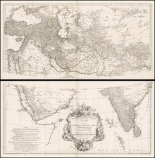
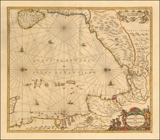
This late 17th-century map details the Bay of Bengal and contiguous parts of India, Sri Lanka, Bangladesh, Myanmar and Thailand, in a unique westward orientation, extending from the eastern coastlines of India and Sri Lanka to the northern reaches of Sumatra and the contiguous coastline of Thailand.
Rhumb lines, which are lines crossing all meridians of longitude at the same angle, feature prominently in the map. Alongside the rhumb lines, the map is also adorned with intricate drawings of five sailing ships. Additionally, two ornate compass roses enhance the map's navigational utility.
The late 17th century was a period of significant political and commercial change in the Bay of Bengal region. The area, particularly India, was a major hub for trade, with numerous European powers such as the Dutch, British, and French establishing their presence and trading posts. The map also captures the period of historical transition from the late Mughal period in India to the early years of European colonial rule. It reflects a period when local empires like the Ayutthaya in Thailand and the Sultanate of Aceh in northern Sumatra were experiencing pressure from encroaching European powers.
The map vividly portrays the Ava River, which flows through modern-day Myanmar. Sitting at the confluence of the Ava River is Pegu, an essential city in the region's history. During the late 17th century, Pegu was the capital of the Bago Region in the Kingdom of Burma and a key trading post, particularly for gems and teak. The city's representation hints at its significance as a commercial and political hub during this period.
Further down the coastline, another important city, Aracam, lies on the Martaban River. Aracam (likely a reference to the city now known as Yangon or Rangoon) served as a critical port, trading in goods like rice, cotton, teak, and precious stones.
Across the bay in the eastern part of India, the map shows the city of Bengala on the Cosmin River. This city likely represents a historical reference to the city of Dhaka in Bangladesh, which was a major center for the muslin trade in the Mughal Empire.
Lastly, the city of Ougely, known today as Hooghly, is depicted on the banks of the Bhagirathi-Hooghly river in West Bengal, India. Hooghly was a significant trading post under the protection of the Mughal Empire, and later became a point of interest for European traders. It is one of the cities that marked the early presence of European powers, including the Portuguese, Dutch, and the British, and their commercial ambitions in India. Over time, Hooghly would give way to the name Calcutta and today Kolkata.
Each city's inclusion in this map reflects the vital role they played in the trade routes of the Bay of Bengal and their connection with the wider world. They stand as testament to the bustling maritime trade and the intense cultural exchange occurring during this time, painting a vibrant picture of economic activity and political dynamics in the late 17th-century Bay of Bengal region.
Jan Janssonius (also known as Johann or Jan Jansson or Janszoon) (1588-1664) was a renowned geographer and publisher of the seventeenth century, when the Dutch dominated map publishing in Europe. Born in Arnhem, Jan was first exposed to the trade via his father, who was also a bookseller and publisher. In 1612, Jan married the daughter of Jodocus Hondius, who was also a prominent mapmaker and seller. Jonssonius’ first maps date from 1616.
In the 1630s, Janssonius worked with his brother-in-law, Henricus Hondius. Their most successful venture was to reissue the Mercator-Hondius atlas. Jodocus Hondius had acquired the plates to the Mercator atlas, first published in 1595, and added 36 additional maps. After Hondius died in 1612, Henricus took over publication; Janssonius joined the venture in 1633. Eventually, the atlas was renamed the Atlas Novus and then the Atlas Major, by which time it had expanded to eleven volumes. Janssonius is also well known for his volume of English county maps, published in 1646.
Janssonius died in Amsterdam in 1664. His son-in-law, Johannes van Waesbergen, took over his business. Eventually, many of Janssonius’ plates were sold to Gerard Valck and Pieter Schenk, who added their names and continued to reissue the maps.