


|
||

|

|
|

|
One of the Earliest American Maps of Lake Superior, Prepared for the Mining Boom That First Drew U.S. Interest to the Lake.
Superb lithographed map of Lake Superior by Michigan's best mapmaker, John Farmer. No example of this map has been offered on the market since the Streeter Sale in 1969.
The map includes information from the Government Survey of the Lake Superior Land District, which was approved in 1847 and greatly expanded the geographic knowledge of the region.
US Survey of the Lake Superior Land District
N. King Huber, The Geologic Story of Isle Royale National Park:
In 1847 the U.S. Congress authorized a survey of the vast Lake Superior Land District to determine its mineral potential, and the result of this survey was the first series of comprehensive reports on the geology of the region. Charles T. Jackson's report of 1849 contains the first map of Isle Royale to show in a very general way the different rock types present on the island. Two following reports, both by John W. Foster and Josiah D. Whitney in 1850 and 1851, include an improved geologic map of Isle Royale and a wealth of information on the early mining activities on the island.
19th Century Mapping of Lake Superior
The modern surveying of Lake Superior began in the first half of the 19th century and produced the following cornerstone maps:
1828. Lt. Henry Wolsey Bayfield. Survey of Lake Superior.
1847. T. W. Bristol. Chart of Lake Superior, Reduced from the British Admiralty Surveys, with corrections on the South Shore, from the U.S. Surveys. By T.W. Bristol 1847
1847. John Farmer. A Geological Map of the Mineral Region From the Official Plats of the United States Surveys and Chart of Lake Superior . . .
1849. Clarence T. Jackson. Geological and mineralogical reports: U.S. 31st Cong., 1st sess., House Ex. Doc. 5
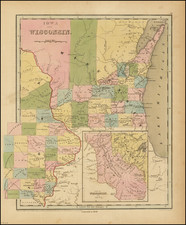
1849. John Farmer. Map of the States of Michigan and Wisconsin embracing a great part of Iowa and Illinois and the whole Mineral Region with a Chart of the Lakes.
This is an update of Farmer's 1847 map of Lake Superior, first issued in only the western sheet, with the eastern sheet added perhaps in 1849. Despite the title's allusion to "a great part of Iowa and Illinois", the map shows nothing of either state. It seems possible that the map was originally intended as a three-sheet production; Farmer maps are known joining the partial 1847 Lake Superior with the map of Michigan. To our knowledge no two- or three-sheet examples exist.
Insets
The map includes the three insets:
- Map of a portion of Wisconsin and a Part of Minnesota
- Map of Beaver Islands from actual survey
- Plat of Isle Royale as laid out into sections from actual survey by the US
Editions and Rarity
The map was first published under a different title in 1847 and revised, '49, '52, '55, '56, '57, and '58 (the present example). The first edition did not include the inset maps but was important in its own right as one of the first two American maps of Lake Superior.
Although the map was published in numerous editions, it is extremely rare today, with no examples having appeared at auction or in dealer catalogs since the Streeter Sale (1969, $100)
John Farmer
John Farmer (1798-1859) was a surveyor and mapmaker based in Detroit, Michigan. To this day he remains the most important mapmaker in Michigan's history. Michigan State provides an in-depth timeline of Farmer's life here .
John Farmer first became a school teacher and taught map drafting among other topics in upstate New York.
At the time, Michigan Territory was in need of teachers. In December 1821 the board of University of Michigan in Detroit (still only primary and secondary education) offered Farmer a position as head of the Lancasterian School.
Trained as a draftsman, Farmer supplemented his income by copying surveyor's township maps and selling the maps to new settlers. He also drew for the Treasurer of the United States a map of Michigan’s first real road, which had been funded by the federal government and assisted Orange Risdon in his map of the surveyed part of Michigan. When Risdon’s project stalled, Farmer ended up publishing his own detailed map of the state in 1826.
By 1830, Farmer had created a new large format map of Michigan which had so much detail that the engraving of the map had to be outsourced to engravers in New York City. This Map of the Surveyed Part of the State of Michigan depicts in great detail the southern half of Michigan’s lower peninsula.
Farmer also produced regional maps starting in 1835 when both Michigan and Wisconsin were still mere territories, ontinuously revising them over the years to reflect changes in development. At the time of his death nearly 25 years later he was still producing a Michigan & Wisconsin map, now titled Map of the States of Michigan and Wisconsin, embracing a great part of Iowa and Illinois and the whole mineral region with a chart of the lakes: Exhibiting the sections, the geological formations, and the general topography.
After a few years Farmer sold the publishing rights to his maps to eastern publisher J. H. Colton and turned his attention to mapping new communities and became involved in the formation of a Detroit Board of School Inspectors.
In 1844, Farmer issued the first edition of his The State of Michigan and the Surrounding Country. This map contained extreme detail of every surveyed square mile, every stream, swamp, and every road and trail and would be published by the Farmer family for the next 30 years.
Farmer died March 24, 1859 in Detroit, Michigan. His widow Rachel Farmer and sons Silas, Arthur and John carried on the business for some time afterward. Maps published after John Farmer's death, however, never maintained the detail and currency of his former work.
![[Hastings, Minnesota]](https://storage.googleapis.com/raremaps/img/small/92128.jpg)
![[ St. Paul, Minnesota - Harley Davidson ] Route of the Winter Carnival Grande Parade -- Saturday January 27th. 1940 . . . .](https://storage.googleapis.com/raremaps/img/small/102073.jpg)
![[Hand Drawn Map] Le Golfe de Mexique avec les Pays Circonvoisins](https://storage.googleapis.com/raremaps/img/small/91580.jpg)