This item has been sold, but you can enter your email address to be notified if another example becomes available.


|
||

|

|
|

|
Stock# 52590
Description
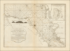
Decorative map showing the primary British Islands in the Indian Ocean and the Straits of Malacca.
Includes two detailed maps of Singapore, one of the Island and one of the town and harbor.
The largest map is Sri Lanka, with smaller maps of Malacca, Island of Singapore, town and harbor of Singapore, positions of the British settlements in the Malay Peninsula, Penang and Island of Labouan.
The vignettes include Malay and Singalese dress, birds, boar and elephant hunting and a view of Colombo.
Includes seven maps on one sheet, surrounded by vignettes, published in 'The Royal Illustrated Atlas, Of Modern Geography .
![[India] Calecut Nova Tabula](https://storage.googleapis.com/raremaps/img/small/87771.jpg)
![[Northwestern India & Pakistan] Tabula Asiae IX](https://storage.googleapis.com/raremaps/img/small/46402.jpg)