


|
||

|

|
|

|
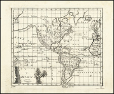
America as Atlantis
Unrecorded state of Sanson's Map of the Island of Atlantis -- the modern continents of North and South America.
Fascinating map of America, published by Mortier Nicolas Sanson, purporting to show the Western Hemisphere about 200,000 years ago before the earliest human civilizations.
The map reflects the populating of the lost continent of Atlantis in the 17th Century. The map shows the divisions of the land masses, as divided by the god Neptune, among his ten sons.
Thule island is shown, which at the time was believed to be the source of Nordic races, based upon the work of Heinrich Schliemann. Schliemann had taken Homer's Iliad and Odyssey and their accounts of the Trojan Wars to be literal truth. He then discovered ancient Troy in Asia Minor.
Atlantis was first described by Plato about 400 B.C. Over the next 2300 years, many other scholars and pseudo intellects championed various elements of the legend. Among the more fantastic modern theories include those who believe that Atlantis is an island in a lake in Bolivia, a part of the Hollow Earth Theory, the site of a visit by Astronauts prior to the birth of Christ and other fantastic theories.
The map shows the cartographic knowledge of the Western World as of the middle of the 17th Century, with California shown as an island, the Dutch discoveries in Australia and New Zealand and the style mythical / conjectural configurations of Alaska, Japan and the lands between.
The present edition is re-engraved, eliminating the Mariette credit, with the addition of the words "Apud Autorum in Aedibus Regus 1699." This edition is not listed by McLaughlin, who notes only editions of 1669 and 1690. Burden notes 5 states (1669, 1677, 1690, undated edition with additional title above Tropic of Capricorn and 1741.
Nicholas Sanson (1600-1667) is considered the father of French cartography in its golden age from the mid-seventeenth century to the mid-eighteenth. Over the course of his career he produced over 300 maps; they are known for their clean style and extensive research. Sanson was largely responsible for beginning the shift of cartographic production and excellence from Amsterdam to Paris in the later-seventeenth century.
Sanson was born in Abbeville in Picardy. He made his first map at age twenty, a wall map of ancient Gaul. Upon moving to Paris, he gained the attention of Cardinal Richelieu, who made an introduction of Sanson to King Louis XIII. This led to Sanson's tutoring of the king and the granting of the title ingenieur-geographe du roi.
His success can be chalked up to his geographic and research skills, but also to his partnership with Pierre Mariette. Early in his career, Sanson worked primarily with the publisher Melchior Tavernier. Mariette purchased Tavernier’s business in 1644. Sanson worked with Mariette until 1657, when the latter died. Mariette’s son, also Pierre, helped to publish the Cartes générales de toutes les parties du monde (1658), Sanson' atlas and the first French world atlas.
![[Okeania] (Greek)](https://storage.googleapis.com/raremaps/img/small/41765.jpg)
![La America Dispuesta segun las ultimas y nuevas observationes de las Accademias, y de Paris, y de Londres [Bay or Sea of the West--Very Rare]](https://storage.googleapis.com/raremaps/img/small/75936.jpg)
![Amerique Septentrionale divisee en Ses Principales parties . . . . 1674 [Rare First State]](https://storage.googleapis.com/raremaps/img/small/99317.jpg)