|
||

|

|
|

|
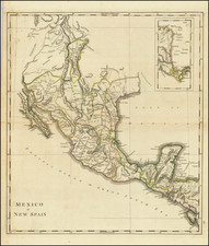
Rare map of Mexico, Texas and the Southwest, from an early edition of Philip's Imperial Atlas.
This map is issued shortly before the Gadsden Purchase, and shows a very oddly configured Texas, bounded by a massive Indian Territory and New Mexico Territory, with most of Southern California.
The detail in Texas includes Ft. Parker, Ft. Houston, Frankfurt, Cincinnati, Austin, Richmond, Houston, Texana, Gonzalez, Franklin, Liberty, Crocket, Washington, Bolivar and some other early interesting place names.
Excellent details in western Arkansas and Indian Territory, including the names of a number of settlements between the Missouri and Arkansas Rivers. Excellent detail in the Rocky Mountains, extending north to the sources of the Rio Grande del Norte and Highest Peak. Sevier Lake is shown, along with a few phantom lakes in Utah. The Inconstant River flows from the Colorado River northwest toward Mono Lake, which is not named.
The watershed west of the Rocky Mountains is quite unusual.
This is the second example of the map we have seen in more than 20 years.