


|
||

|

|
|

|
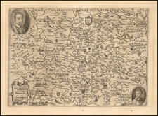
Fine Large Format Map of Corsica, From the Library of General Nicolas Charles Oudinot
Finely detailed map of Corsica, based on the first modern surveys carried out under Colonel Jean Joseph Tranchot from 1774 to 1790. The French Depot de La Guerre spent nearly a century trying to improve and correct the original survey; it is a landmark in the history of surveying and the history of Corsica.
The technical detailing and finely calculated triangulation show through on the map. The island of Corsica is laid out, its mountainous interior evident in the many ridges and ravines that shade the terrain. In the lower left is a table of the various villages and communities of the island, as well as the scale. The table of villages continues in the lower right corner, which also has the key and a table showing the historical divisions of Corsica. In the upper right corner is a table with the locations of the principal points used to complete the triangulation. Finally, in the upper left corner is an inset map showing the triangles themselves, as well as how they connect to the grids of Sardinia and Tuscany. There is also a small-scale map of the region.
The Corsican survey and Jean Joseph Tranchot
Corsica has been continuously occupied since the Mesolithic era and was the site of frequent invasions: Carthaginians, Etruscans, Romans, Vandals, Ostrogoths, Byzantines, Lombards, Franks, Pisans, North African pirates, Genoans, and Ottomans. In 1729, a peasant revolt grew to revolution against the Republic of Genoa. For 26 years the Corsicans fought for their independence, which they attained in 1755. The Corsican Republic lasted until 1769, when the island was conquered yet again, this time by France, who annexed the island from Genoa in 1768. It was officially integrated into the French nation in 1789.
During the French Revolution, Corsican freedom fighters invited the British to help them eradicate the French; they did so in 1794 and declared the Anglo-Corsican Kingdom. The Kingdom only lasted two years, as the British withdrew from Corsica in 1796, effectively handing the island back to the French. Corsica's influence on France was outsized in that it was the birthplace of Napoleon Bonaparte.
The survey of Corsica was a priority for France; the goal was to better map the island using triangulation to create a grid like the one used in the French survey a century before. However, the remoteness of the island and its rough geography made the survey particularly difficult. The task fell to Jean Joseph Tranchot to correctly measure the baselines and establish the latitude and longitude of the island. Remarkably, he was able to measure baselines with an astonishing degree of accuracy, despite faulty instruments. He also joined the geodesy of Corsica with Sardinia and Tuscany.
Jean Joseph Tranchot was born in Koeur-le-Petite, the son of a carpenter. The Corsica survey was his first experience with triangulation on a large scale. He was rewarded for his efforts with recognition from the Academie des Sciences. Next, he worked with Pierre Mechain on the triangulation between Dunkirk, Paris, and Barcelona. In 1794, he continued to work for the Depot de la Guerre, who had also been impressed by his Corsica survey. He was given the rank of Colonel and put in charge of the mapping of France's departments that adjoined the Rhine. That project took from 1801 to 1814. Tranchot suffered a stroke in 1815, killing him.
In all of his projects, but especially in Corsica, Tranchot innovated. His improvements to instruments and his methods of triangulation helped to modernize surveying and mapmaking, which is why it took so long for his work to be superseded; it was not until 1873 that the Depot de la Guerre issued a new official map of Corsica. His legacy shows in this brilliantly detailed map.
General Nicolas Charles Oudinot
A final detail that gives this map particular importance is the identity of its former owner, Nicolas Charles Oudinot, 1st Comte Oudinot, 1st Duc de Reggio (1767 - 1848), and a Marshal of France. A fierce fighter, the man was wounded no less than 34 times during his military career!
The only one of nine siblings to live past childhood, Oudinot joined the army without a noble pedigree, and therefore without a chance of high promotion. That all changed in 1792, with the outbreak of the French Revolution. In that year, Oudinot was elected lieutenant-colonel of the third battalion of the volunteers of the Meuse. After transfer to the regular army and admirable service in Belgium, he was promoted to the rank of general in June 1794 after the Battle of Kaiserslautern.
From Belgium he shifted to the German and Swiss fronts, where he fought as a general of division and chief of staff to Andre Massena. Oudinot stood out at the Battle of Monzambano so much so that Napoleon himself presented him with a sword of honor, now known as the Legion d'Honneur. Napoleon did not forget him after he established his empire; now Emperor Napoleon recognized Oudinot again, this time with a Grand Cross of the Legion of Honor.
During the Napoleonic Wars, Oudinot continued to acquit himself commendably. He was elected a member of the Chamber of Deputies, commanded a company of grenadiers nicknamed for him, and fought in battles from Vienna to Poland. In 1808, he was appointed governor of Erfurt and was made a Count of the French Empire. Finally, in 1809, after the Battle of Wagram, he was named a Marshal of France, France's highest military distinction.
Oudinot continued to serve as an administrator in Holland and on the battlefield in the Russian campaign. After Napoleon's fall, Oudinot joined the Bourbon Restoration and stayed loyal to the King even after Napoleon's return in 1815. For his loyalty and service, he was named a peer of the realm. He served until 1823, when he participated in the French invasion of Spain. Then, he turned again to political and administrative appointments; he died while serving as governor of Les Invalides, at the veterans' hospital in Paris.
Provenance
Purchased at auction in Paris, from Artcuriel, Collections from the Castle of Malicorne Marshal Oudinot's Historical Souvenirs, June 13, 2017 (Lot 156).
![(WWII Propaganda Map) Newsmap for the Armed Forces. 257th Week of the War - 139th Week of U.S. Participation. Monday, 14 August 1944. Volume III, No. 17B [and] No. 17F. [on verso:] Let This Do Your Talking!](https://storage.googleapis.com/raremaps/img/small/95408.jpg)
![Carte Nouvelle Des Pais Bas Catholiques Devises en Autrichiens, Franscois en hollandois…MDCCXCII [New Map of the Catholic Low Countries Divided into Austrians, French and Dutch... 1792.]](https://storage.googleapis.com/raremaps/img/small/92341.jpg)

![[ Confederate States of America Naval Flag! ] Pavillons des Principales Puissances](https://storage.googleapis.com/raremaps/img/small/88973.jpg)