
The item illustrated and described below is sold, but we
have another example in stock. To view the example which
is currently being offered for sale, click the
"View Details" button below.


|
||

|

|
|

|
Stock# 52443
Description
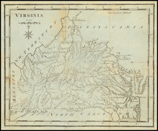
Scott's map of Virginia is one of the earliest obtainable maps of Georgia to appear in an American Atlas.
The map is highly detailed and shows towns, mountains, rivers, etc.
The map appeared in Scott's The United States Gazetteer: Containing an Authentic Description of the Several States. Their Situation, Extent, Boundaries, Soil, Produce, Climate, Population, Trade and Manufactures. Together with the Extent, Boundaries, and Population of their Respective Counties. Also, an Exact account of the Cities, Towns, Harbours, Rivers, Bays, Lakes, Mountains, &c. Illustrated with Nineteen Maps, Printed in Philadelphia by F. & R. Bailey, at Yorick's Head, No. 116.
The map is quite scarce, this being the first example we have ever offered.
![[ Virginia Natives -- The Conjurer ] Praestigiator](https://storage.googleapis.com/raremaps/img/small/98754.jpg)

![[Indiana, Ohio, Kentucky, and Virginia] Amer. Sep. No. 50. Partie des États Unis](https://storage.googleapis.com/raremaps/img/small/93543.jpg)
![[Amherst County Survey of 200 Acres Owned by Captain James Dillard dated 16, 1822]](https://storage.googleapis.com/raremaps/img/small/73745.jpg)
![A New Map of Virginia [Chesapeake]](https://storage.googleapis.com/raremaps/img/small/43053.jpg)