|
||

|

|
|

|
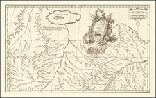
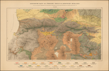
Striking Map of Armenia Made a by Diasporic Armenian a Decade after WWI
This map of Armenia, printed in Armenian, displays the Armenian territory a decade after many Armenians fled from the genocide perpetrated by the Turks beginning in 1915. The author, Antranig H. Patrikian, published the work in Paris, a center of the Armenian Diaspora.
As explained in a key in the lower left corner, Armenia's current borders are marked with a dotted line, while the boundaries of neighboring states are marked with a dashed line. The author is meticulous in differentiating types of settlements: capitals, provincial seats, regional seats, cities, villages, and fortress towns. He also marks sacred sites, usually the seat of Catholicos, who church leaders in the Armenian Church. Additionally, the author marks rivers, mountains, railways, main roads, passes, swamps, and uncultivated land.
The map is quite detailed with densely labeled toponyms and geographic features. The mountainous nature of the region is evident from the many shaded ridges that criss-cross the region. The text is entirely in Armenian except for a note at the top in French explaining that the longitude is calculated east of the Greenwich meridian.
A Diasporic Map
This map is a good example as to how a mapmaker's choices can reveal political leanings. The orthography of the map is in the Western rather than Eastern style. This most likely indicates that that author was not a Soviet sympathizer. In 1918, Eastern Armenia (Western Armenia was occupied by Russian forces) declared itself the First Republic of Armenia. However, the Republic only lasted until 1920, when Turkish nationalists and Soviet forces invaded. In 1922, Armenia, along with Azerbaijan and Georgia, was formally brought into the Soviet sphere. Many Armenians, especially those outside of Armenia, did not recognize or appreciate Soviet rule and this map seems to follow that sentiment. The idea is shored up by the fact that the Soviet Union is not labeled anywhere on the map.
Turkey is also not labeled, most likely as a result of anger over the genocide of 1.5 million Armenians who were living in Ottoman lands during the final days of World War I. When war broke out, the Russians and Ottomans were on opposite sides. Armenia, located as it is at the intersection of the Iranian plateau, the southern Caucasus and Asia Minor, became a place of conflict. The Turks came to view all Armenians, already a suspect minority due to their Christian faith, as possible Russian sympathizers and enemies. Via massacres and death marches, they eradicated the Armenian presence in Anatolia and spurred a global diaspora. Today, 10 million people identify as Armenian yet only 3 million of them live in the state of Armenia itself.
Not only is Turkey not listed, but at times old Armenian names are noted for cities and provinces in what is now Turkey; the author is marking former Armenian presence and reminding his audience that Armenia is not necessarily what its present borders suggest.
Finally, Paris was a major hub of the Armenian Diaspora and was the center of Armenian publication in the 1920s. This map is the product of that diaspora and makes political choices that declare Armenia to be a historical and current state entity despite invasion, genocide, and incorporation.
![Tabula IX Asiae [Pakistan & India] (Title on Verso)](https://storage.googleapis.com/raremaps/img/small/49098.jpg)