This item has been sold, but you can enter your email address to be notified if another example becomes available.


|
||

|

|
|

|
Stock# 52379
Description
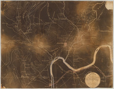
Detailed map of New Orleans in 1770, based upon the report of Captain Philip Pittman.
Pittman's reconnaissance in America resulted in his publication of The Present State Of The European Settlements On The Mississippi; with A Geographical Description of that River Illustrated by Plans and Draughts (London 1770), the first English book on the topography, settlements, and inhabitants of the region. Pittman was a British army engineer. In 1764, he traveled up the Mississippi to New Orleans with Major Arthur Loftus. During his five years in the Gulf coastal region of Louisiana and West Florida he made numerous surveying expeditions.
Condition Description
Minor toning at centerfold.
![[Florida to New Orleans] The North Coast of the Gulf of Mexico from St. Marks to Galveston . . . 1842](https://storage.googleapis.com/raremaps/img/small/83469.jpg)