This item has been sold, but you can enter your email address to be notified if another example becomes available.


|
||

|

|
|

|
Stock# 5225
Description
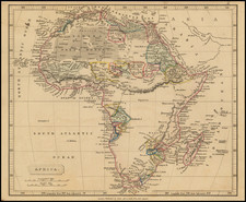
Striking and highly detailed map of Africa, colored by states and colonies, and showing towns, mountains, rivers, lakes, roads, railroads, deserts, islands, etc. One of the best large format maps of Africa of the time period Inset of Cape Verde Islands, Cargados and Mascarnene Islands and Suez Canal. Fabulous colonial map.

![Africa / Lybia / Morland / mit allen kunigsreichen so zu unsern zeiten darin gefunden werden [Afrika/Libyen/Morenland, with all the kingdoms found therein in our time]](https://storage.googleapis.com/raremaps/img/small/95771.jpg)