
The item illustrated and described below is sold, but we
have another example in stock. To view the example which
is currently being offered for sale, click the
"View Details" button below.


|
||

|

|
|

|
Stock# 5224
Description
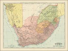
Striking and highly detailed map of South Africa, showing Damara Land, Great Damara Land, Orange Free State, Cape Hope, South African Republic, Swaziland, Tonga Land and Free State of East Africa. Extremely detailed, showing towns, rivers, mountains, roads, Townships, counties, bays, etc. Probably the most detailed American Map of the region produced in the 19th Century.

![[ West Africa ] A Chart of Guinea Describing the Seacoast from Cape de Verde to Cape Bona Esperanca](https://storage.googleapis.com/raremaps/img/small/99962.jpg)
![[ Hottentot ] Ein Hottentot](https://storage.googleapis.com/raremaps/img/small/97666.jpg)