|
||

|

|
|

|
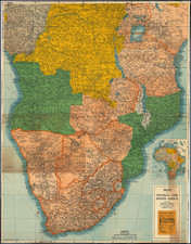
Detailed map of South Africa revised to May 1, 1899.
Stanford's map of South Africa is noteworthy for the meticulous detail given by Stanford and effort to maintain the most up to date mapping of this region. We are aware of several earlier editions, including a map dated November 1, 1894 and June 18, 1895.
The areas under British control in various shades of pink, up a central corridor made up of South Africa, Botswana, Zimbabwe, Zambia and Malawi, and up the east coast through Natal and Zulu Land. Around the British areas were the Germans (Namibia and Tanzania), Portuguese (Angola and Mozambique), the Belgians (Congo Free State) the French (Madagascar) and, of course, the Boers (Transvaal and Orange Free State).
The map identifies: Cape Colony, Natal, Zulu Land, Basuto Land, Orange River Free State, Transvaal, then the "Kalahari Desert," Bechuana Land Protectorat, British Bechuana (Crown Colony), British South Africa, British Central Africa and Nyassa Land Protectorate. From outside of the British borders, the map identifies: Portuguese East Africa (north part called Mozambique) and the south of "German East Africa" (including half of the Tanganijka Lake). To the west, the map identifies: Damara-Land with Great Namaqua Land ("German S.W. Africa", also the British enclave Walfish Bay), Angola (up to Loanda) and British Central Africa. The map also shows the south of the Congo Free State (Belgium) and most of the islands of Madagascar and Comoro.
Edward Stanford (1827-1904) was a prominent British mapmaker and publisher. A native of Holborn in the heart of London, Edward was apprenticed to a printer and stationer at the age of 14. After his first master died, he worked with several others, including Trelawny W. Saunders of Charing Cross. Saunders oversaw young Edward’s early career, ensuring that he became a Fellow of the Royal Geographical Society. Associations with the Society eventually brought Sanders much business and gave him a reputation as a publisher of explorers. As testament to this reputation, the Stanford Range in British Columbia was named for him by John Palliser.
Stanford briefly partnered with Saunders in 1852 before striking out on his own in 1853. He was an agent for the Ordnance Survey, the Admiralty, the Geological Survey, the Trigonometrical Survey of India, and the India Office. He also controlled the maps of the Society for the Diffusion of Useful Knowledge, another lucrative source of income. In 1857, Stanford founded his namesake Geographical Establishment, with Saunders and A. K. Johnston as engravers. Thereafter, Stanford was known for his “library maps”, particularly those of Africa and Asia.
Addresses and Years of Operation:
- 6 Charing Cross, London (1848): Edward Stanford's initial place of employment at Trelawney Saunders' shop.
- 7 and 8 Charing Cross, London (1853): Stanford expanded his shop to these addresses.
- 55 Charing Cross, London (1873): The shop moved to this larger location.
- 12-14 Long Acre, London (1873): Site of the new print works and current flagship store.
- 7 Mercer Walk, London (2019): Stanfords moved to this address, continuing its legacy.
Stanford's work with Chief Cartographer John Bolton, including the 1858 Library Map of Europe, positioned the company as a leader in quality cartography during a time of exploration and colonialism. Their 1862 Library Map of London earned acclaim from the Royal Geographical Society. With the business thriving, Stanford purchased Staunton & Son in 1877 and, upon retiring in 1885, handed over the reins to his son, Edward Stanford II.
As sole agents for Ordnance Survey Maps, the company's influence and reputation grew, culminating in the Stanford’s London Atlas Of Universal Geography, which was presented to Queen Victoria in 1887. The transition into the 20th century saw further integration of retail, print, and cartographic operations at Long Acre.
During World War I, Stanford's became an essential publisher for the War Office. Edward Fraser Stanford took over in 1917, steering the company through the interwar period and innovations, such as the world’s smallest maps in 1922 and the Daily Mail Motor Road Map in 1926.
Withstanding a bombing in WWII, the company continued under the stewardship of John Keith Stanford and was sold to George Philip & Son in 1947. As it adapted to the digital age, Stanfords received the Ordnance Survey Premier Partner status in 2007 and ventured into online mapping and data services.
Stanfords, now an icon for travellers and explorers, has maintained its cultural relevance and retail success well into the 21st century, underpinned by a legacy of entrepreneurial spirit and commitment to cartographic excellence.
![[Luanda, Angola] Eroberung der Statt Loando de Sanct Paolo in Angola in Africa. Gelegen](https://storage.googleapis.com/raremaps/img/small/85194.jpg)