|
||

|

|
|

|
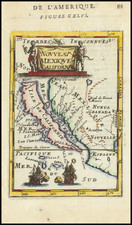
Decorative map of America including California as an Island, a single open Great Lake directly connected to the St. Lawrence, Strait of Anian and no Mississippi River details north of the mid-continent. The map also includes several curious east to west mountains.
The map illustrated an early account of the New World published by Vander Aa, one of the most prolific compilers of information on the early explorations to America, Asia and Africa.
A finely executed copper plate engraving with decorative cartouche.
Pieter van der Aa (1659-1733) was a Dutch mapmaker and publisher who printed pirated editions of foreign bestsellers and illustrated books, but is best known for his voluminous output of maps and atlases. Van der Aa was born to a German stonecutter from Holstein. Interestingly, all three van der Aa sons came to be involved in the printing business. Hildebrand was a copper engraver and Boudewyn was a printer.
![[The First Maps Printed Color] Cartes en Couleur des Lieux Sujets aux tremblements de Terre Dans toutes les parties du Monde Selon le Sisteme de l’impulsion Solaire](https://storage.googleapis.com/raremaps/img/small/52293op.jpg)
![[ World Atlas ] L'Europe en Plusieurs Cartes Nouvelles et Exactes [bound with] L'Asie en Plusieurs Cartes Nouvelles et Exactes [and] L'Afrique en Plusieurs Cartes Nouvelles et Exactses [and] L'Amerique en Plusieurs Nouvelles et Exactes](https://storage.googleapis.com/raremaps/img/small/95822.jpg)