|
||

|

|
|

|
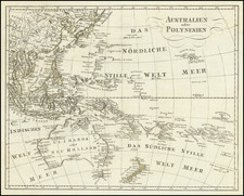
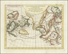
Scarce chart of the Pacific Rim, detailing the new discoveries on both sides of the Pacific.
The map provides a marvelous overview of the discoveries in North America, both Russian and English. The results of the voyages of James Cook, George Vancouver and La Perouse are shown, with the Oregan or Columbia River named, based upon Arrowsmith. The discoveries of McKenzie and Hearne in the Canadian Arctic are also shown.
In the Southern Hemisphere, the map reflects information from Captain Cook's voyage to Australia, showing Port Jackson and other settlements in New South Wales. Other Cook discoveries include Port Sir Fran. Drake, Juan de Fuca Strait, and Nootka Sound. Very early map, soon after the discovery of the Sandwich Islands, accurately depicted. Showing the Pacific Ocean, extending from the northwest coast of North America and the Arctic Sea down to New Holland and New Zeeland, with the dates of discoveries. The map indicates "New South Wales Discd 1770" with many place names, including Port Jackson and Botany Bay. Diemans Land is shown attached to the Australian continent.
Among the more interesting notes is the inclusion of the Corean Sea, a name rarely seen on maps (typically Sea of Corea is more typical).
A nice example of this scarce map.