|
||

|

|
|

|
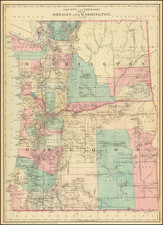
First Edition of the Most Popular Separately Published Map of Oregon of Its Time -- Portland Publisher
Scarce separately issued map of Oregon by J.K. Gill, the leading local seller of books and stationary in Portland at the time.
Gill's maps were frequently updated. This map notes that it was "compiled and drawn by W.H. Galvani Civil Engineer, Portland, Or. This would appear to the be the first edition of this map, which was revised periodically for the rest of the decade.
Shows county boundaries, military and Indian reservations, railroads, lighthouses, stage routes, and wagon roads and trails.
Gill's maps of Oregon and Washington are highly prized for their detail and accuracy, being by far the best separately issued maps of these areas available to collectors.
![[ Rare Early State! ] America's Greatest Scenic Asset The Columbia River Highway [cover title:] Portland Oregon featuring the Columbia River Highway](https://storage.googleapis.com/raremaps/img/small/77120.jpg)
![[ Early Automobile Tourism -- Pacific Coast Highways ] (Strip Maps, etc.)](https://storage.googleapis.com/raremaps/img/small/81461.jpg)
![Map of Oregon Territory. By Samuel Parker. 1838. [with:] Journal of an Exploring Tour Beyond the Rocky Mountains, under the direction of the A. B. C. F. M. 1840.](https://storage.googleapis.com/raremaps/img/small/97939.jpg)
![[Collection of 10 manuscript charts and maps depicting the west coast of North America from Monterey, California, to just north of Salisbury Sound, Alaska.]](https://storage.googleapis.com/raremaps/img/small/98898.jpg)