
This item has been sold, but you can enter your email address to be notified if another example becomes available.


|
||

|

|
|

|
Stock# 51761
Description
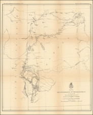
Scare early survey of the Cherokee Lands in Indian Territory, tracking the North Fork of the Canadian River, the Red Fork and Salt Fork of the Arkansas River, Verdigris River, and the Neosho River.
Ft. Gibson and Ft. Smith are shown, along with Union Mission and several Indian villages, including White Hair Village on the Osage Reservation, Osage Village.
One of the earliest obtainable maps of the region, showing the earliest surveys undertaken by the US Government.
Condition Description
Very light foxing.
Reference
Clausen & Friis #188.
![[Texas & Oklahoma] Amer. Sep. No. 55. Partie Des Etats-Unis](https://storage.googleapis.com/raremaps/img/small/93537.jpg)
![[Oklahoma City] Section 22 - T.IIN.-R.3W. Oklahoma City OIl Field](https://storage.googleapis.com/raremaps/img/small/83380.jpg)
![[ Indian Territory / North Texas / Arkansas ] General Topographical Map. Sheet XXIV. Plate CLIX](https://storage.googleapis.com/raremaps/img/small/95113.jpg)

![(Native American Photograph) [Outdoor scene of six Wichita Indians playing cards at a ranch in Minco, Oklahoma Territory, with horse-drawn carriages in the background]](https://storage.googleapis.com/raremaps/img/small/93106.jpg)