|
||

|

|
|

|
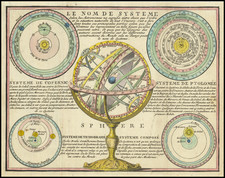
Moveable Compass Included in the First Engraved Sea Atlas
Finely engraved compass, which accompanied Lucas Waghenaer's important Speigel der Zeevaerdt, the first engraved sea atlas.
The document depicts a design for a compass with a moving hand; it is a volvelle, a wheel chart with moving parts called rundells. It is both a directional compass and a star chart. Navigators were expected to find their way by comparing the constellations on the compass' face to the night sky. They would also measure the altitude of the stars, that is, their vertical angle above the horizon to calculate position. The taking of a sight (measuring altitude), with a quadrant (in Waghenaer's era) or a sextant (invented in 1731), when paired with the time the sight was taken, allows a navigator to calculate a position line on a chart.
Volvelles
One of the most interesting aspects of this compass is its moving hand. The word volvelle comes from the Latin word volvere, to turn. Volvelle appeared in many early printed books, including Martin Cortes' Breve Compendio de la sphera y de la arte de navegar (1551) and Peter Apian's Cosmographia (1564). However, volvelles are older than printing itself.
Volvelles have ancient origins and were part of Arabic scholarship in the medieval period. Volvelles first entered European manuscript culture in 1302, thanks to writer, artist, and mystic Ramon Llull. Llull lived in Majorca and was a religious philosopher. His first volvelle was made to produce combinations of nine letters that would represent the nine names of God. Another of his volvelles more closely mirrors this one; it used the position of the stars to calculate time at night. Rather than find a ship's position, Llull's star volvelle was meant to calculate the precise times to administer medicine.
Most volvelles were used for calculation of some sort, particularly for astronomical measurements. Waghenaer's volvelle is in this vein. This volvelle is not only beautiful and informative, it is also extremely rare. Due to their moving parts, vovelle are at high risk of wear and tear; they are frequently ripped, if they were completed by a book-owner in the first place, and survive at very low rates. The existence of this one is a uncommon treat indeed.
Waghenaer and the waggoner
Lucas Janszoon Waghenaer (c. 1533-1606) was a Dutch marine cartographer and navigator. He grew up in the important port of Enkuizen, which explains his proclivity for navigation and the sea. He actually served at sea from 1550 to 1579, which increased his practical knowledge of sailing and charting.
His first publication was the famous Speigel der Zeevaerdt, where this compass featured. The charts and illustrations were engraved by the famous van Doetecum brothers and published by Plantin as a two volume work from 1584 to 1585. The work covers the coastline from the Zuider Zee to Cadiz, that is, most of the western coast of Europe. It also shows the North Sea and the Baltic. Waghenaer's work fulfilled a real need on the part of sailors and merchants who were dependent on navigation for their lives and livelihoods. The work was popular across Europe; it appeared in Dutch, French, and German editions and was re-released for decades.
Somewhat surprisingly, the Speigel was the first time much of the English coastline appeared in print. Waghenaer's sea atlas included the coast from Wash to Cornwall. The importance of the work was quickly grasped by the Earl of Effingham, then Lord High Admiral, who had the plates re-engraved and the text translated into English as the famous Mariner's Mirrour, published in 1585.
Waghenaer's innovative combination of detailed charts with complete sailing directions set a precedent and model for subsequent sea atlases, which came to be called waggoners. Waghenaer himself published more works, specifically Thresoor der Zeevaert ( Treasure of navigation) in 1592 and the Enchuyser zeecaertboeck (Enkhuizen sea-chart-book) in 1598. He died in 1606.
Koeman, C. "Lucas Janszoon Waghenaer: A Sixteenth Century Marine Cartographer." The Geographical Journal. Vol. 131, No. 2 (Jun., 1965), pp. 202-212.
Finely engraved compass, which accompanied Lucas Waghenaer's important Speigel der Zeevaerdt, the first engraved sea atlas.
Waghenaer (c. 1533-1606) was a Dutch marine cartographer and navigator. He grew up in the important port of Enkuizen. From 1550-1579 he served at sea, increasing his practical knowledge of sailing and charting. His first publication was the famous Speigel der Zeevaerdt, or Mariner’s Mirrour, which appeared in 1584. The work was reprinted and translated into several European languages. The combination of detailed charts accompanied by sailing directions set a precedent and model for subsequent sea atlases, which came to be called waggoners. Waghenaer published two other works, Thre
![[English Edition!] Nova Totius Terrarum Orbis Geographica Ac Hydrographica Tabula Auct. Henr: Hondio. . . . 1630](https://storage.googleapis.com/raremaps/img/small/78002.jpg)
![Flags of the British Mercantile Marine [Cover Title]](https://storage.googleapis.com/raremaps/img/small/93745.jpg)
![[Signed Political Satire Artwork] Vietnam ... Vietnam ... Vietnam ...](https://storage.googleapis.com/raremaps/img/small/68726.jpg)