This item has been sold, but you can enter your email address to be notified if another example becomes available.


|
||

|

|
|

|
Stock# 51573ac
Description
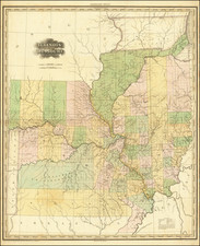
Attractive large hand-colored lithographed folding map of Minnesota, published in St. Paul in 1878. The map is hand-colored by county.
Even in the 1870s, the surveying blocks only extend over about 4/5ths of the state, with much of Beltrami, Kittson, St. Loius, and Lake Counties still unmapped. The map includes rough outlines of Red Lake and Lake Vermillion, but the Boundry Waters and the US-Canada border is remarkably loosely rendered for a later commercial map.
W. P. Jewett was a member of the Jewett publishing company, which played an important role in 19th century Upper Midwest mapmaking.
Condition Description
Folding map with original gilt-lettered cloth folder.
![[ Mille Lacs Lake, Minnesota ] Thomas W. Allison Milaca, Minn. Reference: The Security State Bank Princeton, Minn.](https://storage.googleapis.com/raremaps/img/small/101935.jpg)