


|
||

|

|
|

|
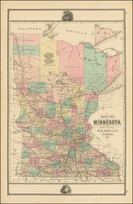
Rare and early St. Paul-published map of Minnesota, by the state's foremost early map publisher.
The map includes an inset titled "Vicinity of St. Paul, and Minneapolis." The inset shows local train and road routes, covering much of Hennepin and Ramsey Counties.
The map is colored by county and shows Incorporated Cities, Township and Railroad Stations, Post Offices, Completed and proposed railroad lines and county boundaries. A ridge line in Northern Minnesota notes, "Dividing Ridge between the waters flowing into the Hudson's Bay and the Gulf of Mexico."
The present map is closely related to another 1872 map, by A. J. Reed. Click+here+to+see+that+map. Rice and Reed originally partnered on an 1871 map of the state, probably the predecessor to the present map, but may have gone their separate ways in 1872. Some sources suggest that this is the year that Reed officially joined Rice's company.
The earliest maps of Minnesota printed in the state were printed circa 1855, but there was very little activity until the mid-1870s. G. J. Rice and Joseph Sewell seem to be the only large-scale commercial mapmakers in Minnesota prior to 1875.
![[First Map of the Mississippi River] Carte de la decouverte faite l'an dans l'Amerique Septentrionale](https://storage.googleapis.com/raremaps/img/small/93571.jpg)
![Comparative Size of Lakes and Islands [Great Lakes, Cuba, Formosa, Ireland, Sicily, Cyprus, Vancouver, Sandwich Islands, Puerto Rico, Corsica, Sardinia, Balearics, Malta, etc]](https://storage.googleapis.com/raremaps/img/small/92574.jpg)
![Partie De L'Amerique Septent? Qui comprend La Nouvelle France ou Le Canada . . . [Large Great Lakes Inset]](https://storage.googleapis.com/raremaps/img/small/48752.jpg)