|
||

|

|
|

|
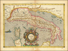
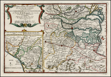
The Valleys of Lucerna, San Martino, and Perosa by Valerius Crassus
Rare map of the Piemonte region of Italy, which appeared in Samuel Morland's The History of the Evangelical Churches of the Valleys of Piemont. Containing a most exact Geographical Description of the Place, and a faithfull Account of the Doctrine, Life, and Persecutions of the Ancient Inhabitants. Together, with a most naked and punctual Relation of the late bloudy Massacre, 1655. And a Narrative of all the following Transactions, to the Year of Our Lord, 1658.
Oriented with west at the top, the map provides a marvelous topographical depiction of the region covered by the modern province of Cuneo in Italy. The map shows the highest peaks of the Alps at the top (south), with the headwaters of several rivers, including the Po at the left (south) shown.
The map is drawn from a map of the three valleys of Lucerna, San Martino, and Perosa, drawn in 1640 by Valerius Crassus.
One of the earliest regional maps of Italy printed in Great Britain.