|
||

|

|
|

|
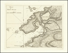
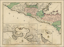
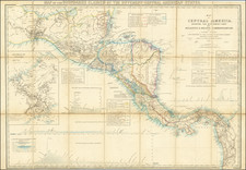
Highly detailed map of the Isthmus of Panama, published by the British Admiralty.
Extending from Mosquito Bay in the Caribbean Sea to Panama Bay in the Pacific, the map provides a remarkable topographical treatment of the region.
This British Admiralty chart was published four years after construction had begun on the Panama Canal by French diplomat Ferdinand de Lesseps. The initial construction of the canal by the French began in 1881 and was abandoned in 1889 as a result of bankruptcy and a high mortality rate among workers due to disease and accidents.
The map also shows the Panama Canal railway, which was built by American investors between 1850-55, and was integral in the building of the canal years later. The chart shows the extreme topography between Panama City and Colon and gives good hydrographical detail of the surrounding bays. Engraved by Edward Weller and sold by J.D. Potter.
History of the Panama Canal
The first mention of a canal across the Isthmus dates to 1534, when the Charles V, the Holy Roman Emperor and King of Spain ordered a survey of a proposed route to shorten the distance between Peru and Spain. In 1788, Thomas Jefferson suggested that the Spanish should consider such an endeavor, and the Spanish expedition undertaken by Alessandro Malaspina between 1788 and 1793 spent some time in the region, allowing Malaspina to set forth a plan for the construction of the Canal.
Between the 1840s and 1870s, a number of American, British and French proposals were made, culminating the commencement of work on the construction of the canal, as a result of the success of the Suez Canal. After two French companies failed to complete the route. In 1902, the French were actively seeking American involvement in the project.
On January 22, 1903, the Hay-Herrán Treaty was signed by United States Secretary of State John M. Hay and Colombian Chargé Dr. Tomás Herrán. For $10 million and an annual payment, the Treaty granted the United States a renewable lease in perpetuity from Colombia on the land proposed for the canal. The treaty was ratified by the U.S. Senate on March 14, 1903, but the Senate of Colombia did not ratify it. Bunau-Varilla told President Theodore Roosevelt and Hay of a possible revolt by Panamanian rebels who aimed to separate from Colombia, and hoped that the United States would support the rebels with U.S. troops and money. Roosevelt changed tactics, based in part on the Mallarino-Bidlack Treaty of 1846, and actively supported the separation of Panama from Colombia and, shortly after recognizing Panama, signed a treaty with the new Panamanian government under similar terms to the Hay-Herrán Treaty.
On November 2, 1903, U.S. warships blocked sea lanes for possible Colombian troop movements en route to put down the rebellion. Panama declared independence on November 3, 1903. The United States quickly recognized the new nation. On November 6, 1903, Philippe Bunau-Varilla, as Panama's ambassador to the United States, signed the Hay-Bunau-Varilla Treaty, granting rights to the United States to build and indefinitely administer the Panama Canal Zone and its defenses. This is sometimes misinterpreted as the "99-year lease" because of misleading wording included in article 22 of the agreement.
Rarity
The map is quite rare on the market. OCLC locates only 2 copies (Cambridge University and British Library).
The British Admiralty has produced nautical charts since 1795 under the auspices of the United Kingdom Hydrographic Office (HO). Its main task was to provide the Royal Navy with navigational products and service, but since 1821 it has also sold charts to the public.
In 1795, King George III appointed Alexander Dalrymple, a pedantic geographer, to consolidate, catalogue, and improve the Royal Navy’s charts. He produced the first chart as the Hydrographer to the Admiralty in 1802. Dalrymple, known for his sticky personality, served until his death in 1808, when he was succeeded by Captain Thomas Hurd. The HO has been run by naval officers ever since.
Hurd professionalized the office and increased its efficiency. He was succeeded by the Arctic explorer Captain William Parry in 1823. By 1825, the HO was offering over seven hundred charts and views for sale. Under Parry, the HO also began to participate in exploratory expeditions. The first was a joint French-Spanish-British trip to the South Atlantic, a voyage organized in part by the Royal Society of London.
In 1829, Rear-Admiral Sir Francis Beaufort was appointed Hydrographer Royal. Under his management, the HO introduced the wind force scale named for him, as well as began issuing official tide tables (1833). It was under Beaufort that HMS Beagle completed several surveying missions, including its most famous voyage commanded by Captain FitzRoy with Charles Darwin onboard. When Beaufort retired in 1855, the HO had nearly two thousand charts in its catalog.
Later in the nineteenth century, the HO supported the Challenger expedition, which is credited with helping to found the discipline of oceanography. The HO participated in the International Meridian Conference which decided on the Greenwich Meridian as the Prime Meridian. Regulation and standardization of oceanic and navigational measures continued into the twentieth century, with the HO participating at the first International Hydrographic Organization meeting in 1921.
During World War II, the HO chart making facility moved to Taunton, the first purpose-built building it ever inhabited. In 1953, the first purpose-built survey ship went to sea, the HMS Vidal. Today, there is an entire class of survey vessels that make up the Royal Navy’s Hydrographic Squadron. The HO began to computerize their charts in the late 1960s and early 1970s. In 1968, the compilation staff also came to Taunton, and the HO continues to work from there today.