


|
||

|

|
|

|
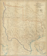
A Landmark Map of the Transmississippi West
Nice example of Rufus Sage's important map of the American West and Texas, based upon his travels west of the Mississippi River between 1841 and 1843.
Referred to by Wagner as "perhaps the rarest of Cartographical delineations of the Western Country," Rufus Sage's finely executed map is one of the earliest snapshots of the West following the resolution of the Northern border with Canada and on the eve of War with Mexico, including the first accurate depiction of the final boundary between Oregon Territory and British America (Canada). The map is also the earliest attempt to show the emigrant trails to the west and California, and one of the only printed maps to provided a detailed account of Jacob Snively's expedition on behalf of the Republic of Texas in 1843.
One of the most meritorious elements of the map is that Sage is careful not to include speculative information and for this the map has become among the most important maps prior to the Gold Rush. Early trade routes are depicted, as are early towns, a few roads in the west and the location of early settlements.
The map provides the most accurate delineation of the emigrant trails to California and Oregon to date. Sage's work is also noteworthy for the accuracy of his presentation of the major rivers between the Rocky Mountains and the Mississippi River, far surpassing the work of any contemporary traveller of the 1840s. The map also shows a number of the major forts in the west, including the trading forts operated by the fur traders (such as Ft. Laramie, Bent's Fort, Fort Pueblo and St. Vrain's Fort) and forts then operated by the US Government.
In Texas, the map identifies several battles and other notes along the Santa Fe Trail from Chihuahua, relating to Jacob Snively's Expedition on behalf of the Republic of Texas against Mexican Traders in the region, in retaliation for the mistreatment of Texans resulting from the Texan Santa Fe expedition, the Mier expedition, and General Woll's raid on San Antonio. These notes include the location of three battles fought against the Mexicans. The map also shows the location of the encounter between Snively and U.S. Dragoon Captain Philip St. George Cooke near the Arkansas River, where Snively's force was accused of violating the sovereignty of the United States and forced to disband (and later regroup under the command of Charles Warfield). Later, Cooke elected to simply escort a portion of the expedition to Independence, Missouri. A smaller group would continue the expedition for another month, disbanding at Fort Bird, Texas in July of 1843.
There is one other note relating to the Snively expedition, which notes "volunteers disbanded" just south of Bent's Fort on the Arkansas River. This is where Rufus Sage initially joined the Snively expedition in February 1843, while Snively was still recruiting volunteers. Sage would serve as a scout on the expedition in New Mexico, including the battle near Mora, New Mexico, which is identified on the map in March 1843. Shortly after the battle, Sage and other mountain men recruited at Bent's Fort left the expedition and returned northward.
In Oregon Territory, an interesting set of regional names are used, including South Oregon, Western Division, Eastern Division, Middle Division, and Northern Division. These names appear in Philip Leget Edwards Sketch of the Oregon Territory . . . (1842). These divisions are also utilized in Sage's text, but do not seem to have gained currency thereafter.
In the area of present-day Nevada and Utah states, "This region has never been explored, and is supposed to be impassable on account of its immense plains of sand, alike destitute of vegetation and water." In California, Sutter's Nueva Helvetia is shown, as is the trail from California to Oregon. The Upper California missions are noted.
Rufus B. Sage (1817 - 1883) was born in Cromwell (later Middletown), Connecticut, the youngest of seven children. In his early years, Rufus became a printer and writer. Working for a series of newspapers between the mid-1830s and 1839 and moving progressively farther west into Ohio. In early 1840, Sage became a part of the successful Presidential campaign of William Henry Harrison, publishing several campaign newspapers.
Following the election, Sage's strong desire to explore the vast region beyond the Missouri frontier compelled him to organize a party to explore the west. Sage travelled west with his group and later joined a party of Indian traders. This period was later described in his famous recollections entitled Scenes in the Rocky Mountains. In July of 1844, he returned to Columbus and returned to his life as a writer and publisher.
Rufus Sage wandered in the Rocky Mountains from 1841 to 1843. He travelled extensively in the major fur trapping regions and associated with trappers, traders, Indians, hunters, and soldiers, becoming perhaps the single most well travelled literate man in the west prior to the Gold Rush in 1849. His writings are among the most important overland narratives. Sage set out from Westport in the summer of 1841 with a fur caravan, later visiting New Mexico, witnessing the disaster of the Snively expedition, and joining the end of the 1843 Fremont expedition.
He returned to Ohio in time to take a vigorous if not futile role in the election of 1844, supporting Henry Clay. He wrote his book in 1845. The story of the publication of this work and its subsequent sale is told by LeRoy Hafen in the introduction to the most scholarly edition of Sage, issued in two volumes by the Arthur H. Clark Co. in 1956. According to Hafen, the publishers of the original edition felt the addition of a map would cost too much, and, at the author's insistence, that a map was printed and sold with the book at a higher rate.
Sage's map, is usually not found with the book. Wheate notes that it is "one of the earliest to depict the finally-determined Oregon boundary...one of the earliest attempts to show on a map the evermore-heavily traveled emigrant road to California." It adds interesting notes on the country and locations of fur trading establishments. Sage was certainly one of the most literate and acute observers of the west in the period immediately before the events of 1846.

![[Central Riverside County] Riverside Quadrangle](https://storage.googleapis.com/raremaps/img/small/83568.jpg)
![[Rare First State] Novissima Tabula Regionis Ludovicianae Gallice dictae la Louisiane . . .](https://storage.googleapis.com/raremaps/img/small/72622.jpg)
![Chart of the Coast of California from San Blas to San Francisco Drawn chiefly from the Spanish Surveys, the Charts of Vancouver &c. the whole much improved by recent observations made by English and French Naval Officers . . . 1854 [Additions to 1862]](https://storage.googleapis.com/raremaps/img/small/58999.jpg)
![[ US-Mexico Border Survey: General Order From the President of the United States Directing William H. Emory to lead the US-Mexico Boundary Survey ]](https://storage.googleapis.com/raremaps/img/small/101837.jpg)