This item has been sold, but you can enter your email address to be notified if another example becomes available.


|
||

|

|
|

|
Stock# 51251
Description
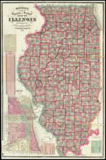
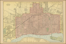
Scarce issued map of the city of Chicago by Rufus Blanchard, one of the leading map makers in Chicago during the 19th Century.
Provides a detailed look at the city of Chicago. A code at the right helps identify transit lines, including:
- Horse Car Lines
- Cable Lines
- Electric Lines
- Elevated Roads
- Railroad Lines
Condition Description
Fold splits, expertly repaired on verso.
![Carte De La Louisiane Et Du Cours Du Mississipi . . . Juin 1718 [1st State!]](https://storage.googleapis.com/raremaps/img/small/59797.jpg)
![North America Sheet IX Parts of Missouri, Illinois and Indiana [and the Sioux District]](https://storage.googleapis.com/raremaps/img/small/84193.jpg)
![[The First Maps Printed Color] Cartes en Couleur des Lieux Sujets aux tremblements de Terre Dans toutes les parties du Monde Selon le Sisteme de l’impulsion Solaire](https://storage.googleapis.com/raremaps/img/small/52293op.jpg)