


|
||

|

|
|

|
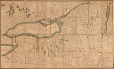
Detailed map focusing on the locations of Fort Ontario and Fort Oswego, first published in 1757.
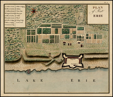
Fort Oswego was an important frontier post for British traders in the 18th century. A trading post was established in 1722 with a log palisade, and New York governor William Burnet ordered a fort built at the site in 1727. The fort established a British presence on the Great Lakes. During the French and Indian War, this fort was captured and destroyed by the French in 1756. The site is now included in the city of Oswego, New York.
Fort Ontario was one of several forts erected by the British to protect the area around the east end of Lake Ontario. The original Fort Ontario was erected in 1755, during the French and Indian War in order to bolster defenses already in place at Fort Oswego on the opposite side of the river. At that time its name was the "Fort of the Six Nations," but the fort was destroyed by French forces and rebuilt by British forces in 1759.
At the conclusion of Pontiac's War, Pontiac urged moderation and agreed to travel to New York, where he made a formal treaty with William Johnson at Fort Ontario on July 25, 1766.
During the American Revolutionary War, a detachment from the 3rd New York Regiment destroyed the fort in July, 1778, after the British abandoned it. The British returned and rebuilt the fort in 1782. There was an aborted attack on the fort by Colonel Marinus Willet in 1783. The British held the fort after the war was over until 1796 after the signing of Jay's Treaty.
From Documentary History of the State of New York, published in 1850, based upon an original published circa 1757.
![[Pennsylvania, New Jersey, New York ] Speciel Land Charte von Pensilvanien, Neu Jersey, Neu York und von denen drey Land-schafften an dem Delaware Fl. In America in Englischer Spr. gedruckt A. 1749 In Europa duffgelegt in Teutsch Spr. zu Francfurt am M. A. 1750.](https://storage.googleapis.com/raremaps/img/small/51958.jpg)
![(Colonial New York) [Deed of Partition of a Tract of 10,200 Acres of Lands to the Eastward of Fort Edward in Charlotte County]](https://storage.googleapis.com/raremaps/img/small/93927.jpg)