


|
||

|

|
|

|
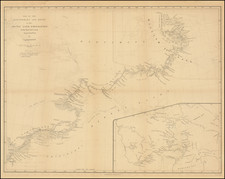
Finely detailed map of the Stikine River, based upon an expedition led by Mineralogist William Phipps Blake in 1863. The map was drawn to accompany the report of W.H. Seward, shortly after the acquisition of Alaska by the United States in 1867.
The map tracks the navigable portions of the river, with numerous glaciers shown, along with topographical features, mountains, etc. The camp locations of the expedition are shown.
The first European to explore the Stikine River was Samuel Black, who visited the headwaters during his Finlay River expedition in 1824. It was more extensively explored in 1838 by Robert Campbell, of the Hudson's Bay Company, completing the last link in the company's transcontinental canoe route. In 1879, the lower third was travelled by John Muir who likened it to "a Yosemite that was a hundred miles long". Muir recorded over 300 glaciers along the river's course. The Grand Canyon of the Stikine has been successfully navigated by less than 50 expert whitewater kayakers. It is considered one of the world's most difficult whitewater rivers in that particular section.
William Phipps Blake was a prominent mining academic and mineralogist of Arizona, formerly professor of the department of mining at the University of California, where he served as head of the geological department and Director of the School of Mines. He was a member of various European scientific bodies and was the author of several works, mostly of a technical character. Among them are: "Tombstone and Its Mines," "Ceramic Art and Glass," "Life of Captain John Mix."
![[ Queen Anne's War - Failed Attack on French Canada -- Petition to Queen Anne from the Colony of New York seeking reimbursement for a failed conquest of New France during Queen Anne's War ] To the Queens most Excellent Majesty . . . 1709](https://storage.googleapis.com/raremaps/img/small/85409.jpg)
![The Coast of Newfoundland From Plancentia to Cape Bonavista [and] A Draught of the River Plata in South America [and] Havana, Harbour [and] the Bay of Honda](https://storage.googleapis.com/raremaps/img/small/38599.jpg)
![[East Coast of Prince Edward Island - Rollo Bay to Wood Islands]](https://storage.googleapis.com/raremaps/img/small/62849.jpg)