
This item has been sold, but you can enter your email address to be notified if another example becomes available.


|
||

|

|
|

|
Stock# 51103
Description
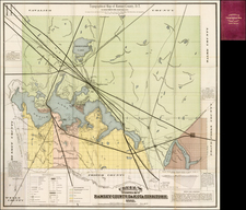
Detailed separately published map of St. Louis and environs, published in St. Louis by Charles Hoelscher Maps and Map Mounting, 203 PIne St., St. Louis.
Oriented with west at the top, the map provides a fine snapshot of the City of St. Louis, showing the area west of the Mississippi River, centered on Forest Park.
The index in red shows Motorbus lines and Street Railways, with a large alphabetical street index.
The map shows St. Louis on the eve of Charles Lindbergh's transatlantic flight and two decades after it hosted the World's Fair.
The map is quite rare on the market. There are no examples listed in OCLC.
![Louisiana [Large-Paper Example]](https://storage.googleapis.com/raremaps/img/small/83278.jpg)


