|
||

|

|
|

|
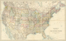
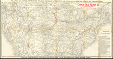
The Second General Land Office Map of the United States
Fine map of the United States, published by the General Land Office in 1865.
This is the second earliest issue of a general United States map by the GLO, following the edition of 1864.
The map shows the progress of the General Land Office's Surveys, primarily in California, Washington, Oregon, New Mexico, Colorado, Nebraska, Kansas and the states along the Mississippi River.
A great map of the United States from the Midwest to the West Coast, meant to accompany the Commissioner's land survey report. The map illustrates the progress of the Public Land Survey and shows land states, territories, land offices, townships, cities, forts and Indian Reservations. Also shown are extensive topographical details, wagon trails and railroad lines with their respective activation dates and proposed rail lines.
This early states of the map are quite scarce on the market -- this is the first example of the map we have handled.