|
||

|

|
|

|
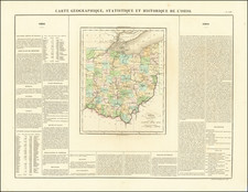
One of the Earliest Maps of Shaker Heights, Ohio -- Showing Its Original Subdivison.
Rare real estate subdivision map for Shaker Heights, Ohio, published shortly after Shaker Heights obtained village status in 1912.
The map is one of the earliest existing subdivision map to show the extent of Shaker Heights as it was planned by the original developers and of the few surviving maps, the first to show a wider-subdivided community in the form which Shaker Heights existed when it obtained Village status in 1912. A review of the maps held by the Shaker Heights Historical Society indicates that the most of the extant early maps of Shaker Heights were published in the 1920s. We note the following maps in the Shaker Heights Historical Society Collection:
- Map of the property of the Shaker Heights Improvement Co., which is focused on the land on and to the north of Fairmount Boulevard, north of the park, which covers a smaller area.
- Shaker Heights parkway frontages and subdivision of south side Cleveland Heights Village, which pre-dates most of the subdivsion of Shaker Heights and covers a smaller area.
- There are also several Fire
The map was produced for The Van Sweringen Company, "The Shaker Heights Syndicate." As noted below, Van Sweringen was the original community developer for Shaker Heights.
A larger inset at the bottom left shows the transportation routes from Shaker Heights Village to various parts of Cleveland.
Shaker Heights
Shaker Heights was established in 1809, and incorporated as a village in 1912. The name "Shaker Heights" has origins in two local sources. The community was laid out on land formerly owned by the North Union Community of the United Society of Believers in Christ's Second Appearing, more commonly known as Shakers. "Heights" refers to the plateau east of Cleveland that rises sharply in elevation from 582 feet above sea level at the base of the Cedar Glen Parkway rising to 950 feet above sea level in nearby Cleveland Heights. Shaker Heights' elevation is 1050 feet above sea level.
Ralph Russell established the North Union Shaker Settlement in 1822 with just over 80 individuals. Between 1826 and 1854, the group dammed Doan Brook, which made Upper and Lower Lake, and established three grist and a sawmills. The colony peaked around 1850 with about 300 settlers, faded away and was closed in 1889.
In 1905, the land was bought by brothers M.J. and O.P. Van Sweringen who envisioned a garden style suburb. The brothers constructed homes, set aside land for churches and schools, and planted trees. In 1906, Shaker Village was started and a Cleveland Syndicate organized by the Van Sweringens to acquire the Villages's 1200 acres for $1,000,000. Originally referred to as Shaker Village, the Village of Shaker Heights was formed on October 27, 1911 and incorporated on February 13, 1912.
Beginning in 1916, the Green-Cadwallander-Long company opened the Shaker Heights Allotment for private sale. A village board was formed which was empowered to regulate architecture, color schemes, construction of multi-family dwellings and placement of businesses. Resale of houses was restricted to approval by the Van Sweringen Company or a majority of the owners of adjoining owners and deeds were restricted for 99 years to keep out undesirable residents.
The Van Sweringens acquired the New York, Chicago and St. Louis Railroad (Nickel Plate Road) in order to secure the right of way needed to establish a rapid transitinterurban streetcar system that would carry residents of Shaker Heights to and from downtown Cleveland. The resulting system was known as the Shaker Heights Rapid Transit.
Rarity
The map is very rare. We note only the example in the Shaker Historical Society. Elizabeth Nord Library Collection.