
![America noviter delineata [ Heightened with Gold Leaf ] By Jodocus Hondius / Jan Jansson](https://storage.googleapis.com/raremaps/img/small/71040.jpg)


|
||

|

|
|

|
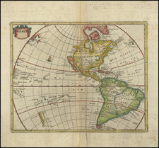
Nice example of the Hondius Map of America.
The map includes a marvelous peninsular California with the Northwest Coast of America stretching almost due westward toward Asia, with over 30 place names. The Rio Grande flows into the Gulf of California and the 7 cities of Cibola are shown.
The map also displays an unusual East Coast of North America, packed full of place names, including Chesdpiooc (Chesapeake), Sanawanook, Hatoraske (Hatteras), Charlefort, Cap de S. Roman, etc. The Great Lakes are not yet shown, nor does Long Island appear.
The map depicts an oversized South America with Indians and animal vignettes in the interior. Includes sailing ships, sea monsters and other decorations.
The present edition of the map is state 3, dated 1631. However, it is the first state without the decorative borders.
Henricus Hondius (1597-1651) was a Dutch engraver and mapmaker, a member of a prominent cartographic family. His father, Jodocus Hondius, was also an engraver and geographer. While working with his father, Henricus was instrumental in the expansion and republishing of Mercator’s atlas, first published in 1595 and republished by Hondius in 1606.
Upon his father’s death in 1612, Henricus and his brother, Jodocus the Younger, took over the business. He set up his own shop in 1621, where he continued to release new editions of the Mercator atlas. Later, he partnered with his brother-in-law, Jan Janssonius, in continuing to expand and publish Mercator’s atlas, which would become known as the Mercator-Hondius-Janssonius atlas. Born and based in Amsterdam, he died there in 1651.
![[ World & Continents ] Typus Orbis Terrarum / Americae Sive Novi Orbis Nova Descriptio / Asiae Nova Descriptio / Africae Tabula Nova / Europae](https://storage.googleapis.com/raremaps/img/small/99250.jpg)
![[The Rarest State] Americae Sive Novi Orbis Nova Descriptio](https://storage.googleapis.com/raremaps/img/small/80521.jpg)