|
||

|

|
|

|
Fascinating group of maps on a single sheet, identifying the lands acquired by the Conner Family in Osage County, Oklahoma, immediately north of Tulsa.
The map was published in Pawhuska, Oklahoma.
The map identifies the lands acquired from Osage Nation members who were originally allocated the lands, which in turn were sold to George Conner and his family, totalling 2,622.60 acres, including
- Adelia Conner
- Victor W. Conner
- Daniel I Conner
The maps show the MVRR (Midland Valley Railroad), Birch Creek, Bever Creek and Frankford.
The note at the bottom reads:
I hereby certify this map is a true correct representation of the allotments of the land of George Conner and his family in Osage County Oklahoma as shown by the records of the Osage Commission
Signed JD Thomas Pawhuska March 6, 1909
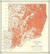
Osage County & Allotment Lands
Osage County was formed in 1907, the same year as Oklahoma Statehood. The county consists of the lands of the Osage Nation.
By the 19th century, the Osage had been forced to move west from the Ohio Valley across the Mississippi River. The Osage became established as a powerful nation in the areas of present-day Missouri and Arkansas between the Missouri and Red rivers, and to the west.
In 1825, they ceded their claim to the land in present-day Oklahoma to the United States government, which included it in a "perpetual outlet to the west given to the Cherokee Nation by the Treaty of New Echota" in 1835. This treaty was to accomplish Cherokee removal to the Indian Territory.
In 1870, the Osage finally prepared for removal from Kansas, after having negotiated payment for their land. They purchased 1.57 million acres (6,400 km2) of their former territory in present-day Oklahoma from the Cherokee. Because they acquired title to the land, they had a stronger position in relation to the US government than did other tribes.
In 1875, the US designated their land as the Osage Reservation. Because the tribe owned the land directly, they retained more control over their affairs than did tribes whose land was held "in trust" by the United States government. This reservation became part of the Oklahoma Territory under the Oklahoma Organic Act of 1890. It became a semi-autonomous district by the Oklahoma Enabling Act of 1906, and Osage County at the time of Oklahoma Statehood in 1907. At that time, there were 2,229 registered Osage members.
As the Osage owned their land, they were in a stronger position than other tribes. The Osage were unyielding in refusing to give up their lands and held up statehood for Oklahoma before signing an Allotment Act. They were forced to accept allotment, but retained their "surplus" land after allotment to households, and apportioned it to individual members. Each of the 2,228 registered Osage members in 1906 (and one non-Osage) received 657 acres, nearly four times the amount of land (usually 160 acres) that most Native American households were allotted in other places when communal lands were distributed. In addition, the tribe retained communal mineral rights to what was below the surface. As development of resources occurred, members of the tribe received royalties according to their headrights, paid according to the amount of land they held.
In 1906, the Osage Allotment Act was passed by U.S. Congress, as part of its effort to extinguish Native American tribal rights and structure, and to prepare the territories for statehood as Oklahoma. In addition to breaking up communal land, the Act replaced tribal government with the Osage National Council, to which members were to be elected to conduct the tribe's political, business, and social affairs.
Although the Osage were encouraged to become settled farmers, their land was the poorest in the Indian Territory for agricultural purposes. They survived by subsistence farming, later enhanced by stock raising. They discovered they were fortunate to have lands covered with the rich bluestem grass, which proved to be the best grazing in the entire country. They leased lands to ranchers for grazing and earned income from the resulting fees.
![[ Idaho Below Montana ] Verein-Staaten am Stillen Ocean… [inset of San Francisco Bay] [Unusual Idaho & California configurations]](https://storage.googleapis.com/raremaps/img/small/99297.jpg)
![Carte Du Canada ou de la Nouvelle France et des Decouvertes qui y ont ete faites . . . [Map of Canada or New France and the Discoveries Made Therein . . .]](https://storage.googleapis.com/raremaps/img/small/94450.jpg)