|
||

|

|
|

|
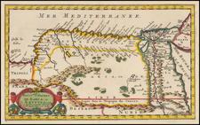
Rare Early Map of North Africa & The Nile River Valley
Striking early modern map of North Africa and Egypt, from the Red Sea, the Nile and Egypt to the Gulf of Libya. Extends up rivers along the Nile to Aden.
Latin text and elaborate decorations on the verso. A nice example, from the 1525 edition of Fries Atlas. First published in Strasbourg by Johannes Gruninger in 1522, Fries map is based upon Waldseemuller's map of 1513.
Lorenz (Laurent) Fries was born in Alsace in about 1490. He studied medicine, apparently spending time at the universities of Pavia, Piacenza, Montpellier and Vienna. After completing his education, Fries worked as a physician in several places, before settling in Strassburg, in about 1519. While in Strassburg, Fries met the Strasbourg printer and publisher Johann Grüninger, an associate of the St. Die group of scholars formed by, among others, Walter Lud, Martin Ringmann and Martin Waldseemuller.
From 1520 to 1525, Fries worked with Gruninger as a cartographic editor, exploiting the corpus of material that Waldseemuller had created. Fries' first venture into mapmaking was in 1520, when he executed a reduction of Martin Waldseemuller's wall-map of the World, published in 1507. While it would appear that Fries was the editor of the map, credit is actually given in the title to Peter Apian. The map, Tipus Orbis Universalis Iuxta Ptolomei Cosmographi Traditionem Et America Vespucii Aliorque Lustrationes A Petro Apiano Leysnico Elucubrat. An.o Dni MDXX, and was issued in Caius Julius Solinus' Enarrationes, edited by Camers, and published in Vienna in 1520.
Fries next project that Fries was a new edition of the Geographia of Claudius Ptolemy, which was published by Johann Koberger in 1522. Fries evidently edited the maps, in most cases simply producing a reduction of the equivalent map from Waldseemuller's 1513 edition of the Geographie Opus Novissima, printed by Johann Schott. Fries also prepare three new maps for the Geographie: maps of South-East Asia and the East Indies, China and the World, but the geography of these derives from Waldseemuller's world map of 1507.
The 1522 edition of Fries work is very rare, suggesting that the work was not commercially successful. In 1525, an improved edition was issued, with a re-edit of the text by Wilibald Pirkheimer, from the notes of Johannes Regiomontanus. After Grüninger's death in 1531, the business was continued by his son Christoph, who seems to have sold the materials for the Ptolemy to two Lyon publishers, the brothers Melchior and Gaspar Trechsel, who published a joint edition in 1535, before Gaspar Trechsel published an edition in his own right in 1541.
Lorenz (Laurent) Fries (ca. 1485-1532) was born in Mulhouse, Alsace. He studied medicine, apparently spending time at the universities of Pavia, Piacenza, Montpellier and Vienna. After completing his education, Fries worked as a physician in several places before settling in Strasbourg in about 1519. While in Strasbourg, Fries met the Strasbourg printer and publisher Johann Grüninger, an associate of the St. Dié group of scholars formed by, among others, Walter Lud, Matthias Ringmann and Martin Waldseemüller.
From 1520 to 1525, Fries worked with Grüninger as a cartographic editor, exploiting the corpus of material that Waldseemüller had created. Fries' first venture into mapmaking was in 1520, when he executed a reduction of Martin Waldseemüller's wall map of the world, first published in 1507. While it would appear that Fries was the editor of the map, credit is actually given in the title to Peter Apian. The map, Tipus Orbis Universalis Iuxta Ptolomei Cosmographi Traditionem Et Americ Vespucii Aliorque Lustrationes A Petro Apiano Leysnico Elucubrat. An.o Dni MDXX, was issued in Caius Julius Solinus' Enarrationes, edited by Camers, and published in Vienna in 1520.
Fries’ next project was a new edition of the Geographia of Claudius Ptolemy, which was published by Johann Grüninger in 1522. Fries evidently edited the maps, in most cases simply producing a reduction of the equivalent map from Waldseemüller's 1513 edition of the Geographie Opus Novissima, printed by Johann Schott. Fries also prepared three new maps for the Geographia, of Southeast Asia and the East Indies, China, and the world, but the geography of these derives from Waldseemüller's world map of 1507.
The 1522 edition of Fries' work is very rare, suggesting that the work was not commercially successful. In 1525, an improved edition was issued, with a re-edit of the text by Willibald Pirkheimer, from the notes of Regiomontanus (Johannes Müller von Königsberg).
After Grüninger's death in ca. 1531, the business was continued by his son Christoph, who seems to have sold the materials for the Ptolemy to two Lyon publishers, the brothers Melchior and Gaspar Trechsel, who published a joint edition in 1535, before Gaspar Trechsel published an edition in his own right in 1541.
![[Pictorial Map of the United Arab Republic] Kharitat Musawwarat al-Jumhuriya al-'Arabiya al-Muttahida / خريطة مصورة الجمهورية العربية المتحدة](https://storage.googleapis.com/raremaps/img/small/55146.jpg)
![(Marakesh) Palatium Magni Regis Maroci In Barbaria [Palace of the Great King of Morocco in Barbary]](https://storage.googleapis.com/raremaps/img/small/53154.jpg)