|
||

|

|
|

|
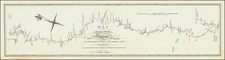
Scarce and highly detailed map of part of Utah in the Salt Lake and Wasatch region, published by Augustus Petermann.
The map names numerous early Utah towns, including:
- Provo
- Salt Lake City (with a town grid)
- Springville
- Brigham City
- Palmyra
- Payson
- Pleasant Grove
- Cedar City
- Lake City
- Welsh Settlement
- Cottonwood
- Kanyon
- Farmington
- Centerville
- Phillips
- Keysville
- Ogden City
- Bingham's Fort
- Holmes
- Haight
- Muhle
- Sessions
Many early roads are shown on both sides of the Wasatch Mountains.
August Heinrich Petermann (1822-1878) is a renowned German cartographer of the nineteenth century. Petermann studied cartography at the Geographical Art-School in Potsdam before traveling to Edinburgh to work with Dr. A. Keith Johnston on an English edition of Berghaus’ Physical Atlas. Two years later he moved to London, where he made maps and advised exploratory expeditions as they set off to explore the interior of Africa and the Arctic.
In 1854, Petermann returned to Germany to be Director of the Geographical Institute of Justus Perthes in Gotha. There, he was the editor of the Geographische Mittheilungen and Stieler’s Handatlas. The Royal Geographical Society of London awarded him their Gold Medal in 1860. He continued his interest in exploration in Germany, fundraising for the German Exploring Expeditions of 1868 and 1869-70, which sought an open Arctic sea. Tragically, he committed suicide in 1878.
![Map of the Missouri Pacific and St. Louis, Iron Mountain and Southern Railway and Connections [Missouri Pacific Railway. St. Louis & All Points East Chair Cars Free Fast Mail Route]](https://storage.googleapis.com/raremaps/img/small/91606.jpg)
![(Texas - Spanish Colonial Era) [Manuscript document of 1692 concerning Bahia del Espiritu Santo on the Texas Gulf Coast, signed by the Viceroy's secretary, Juan Francisco de Vargas Manuel de Lodeña]](https://storage.googleapis.com/raremaps/img/small/95766.jpg)