


|
||

|

|
|

|
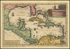
The First Scientific Charting of the Gulf Coast
Detailed sea chart of the Gulf Coast, from the Missisissippi Delta to the Florida Panhandle, published in Paris by Antoine Laval.
The Chart identifies topographical features, soundings, islands and coastal features, along with locating forts at Biloxi, Fort Lewis, Vieux Fort, and Fort Saint Marie. Excellent detail is given or Mobile Bay, Pensacola Bay and others.
Laval's explorations in Louisiana comprised the first truly scientific expedition to the region, undertaken at the height of John Law's Mississippi Bubble Scheme and only 3 years after the founding of New Orleans. The mapping of the Guld Coast was without question the finest printed map to focus on this region to date, based upon several years of close study and observation by the French, even including a reference to the 11 different types of Sandy bottoms along the coastline in the table at the top left.
Antoine-François de Laval (1664 - 1728) was a French astronomer and cartographer. In 1720, he traveled to America, on a mission to make hydrographic, topographic, physical and astronomical observations. In 1728 he published the book Voyage de la Louisiane, which included this map.

![[ Southern Railroads ] Railroad Map of the Southern States Shewing the Southern & Southwestern Railway Connections With Philadelphia. 1862 . . . Prepared by Thomas Kimber Jr., Chairman of the Committee on Inland Transportation of the Board of Trade of Philadelphia](https://storage.googleapis.com/raremaps/img/small/103211.jpg)
