|
||

|

|
|

|
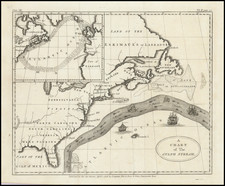
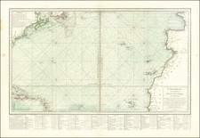
Unrecorded Chart of the North Atlantic, Illustrating the Voyage to Test Jan Hendricksz Jarichs van der Ley's New Method for Finding Longitude at Sea.
Previously unknown sea chart illustrating a "voyage of experiment" from the Netherlands to Iceland, Newfoundland, the Azores, Cape Finisterre (Spain) and back to the Netherlands via the English Channel, intended to test Jan Hendricksz Jarichs van der Ley's innovative method for determining longitude at sea and the chart was part of that innovation.
This rare sea chart extends west to show a significant portion of New France, including toponyms of Canadensis and Terra Nova. The coastlines are drawn with grey lines, not black, to show they are not well known. The rest of the chart shows (moving east) an outline of Greenland and the suggestion of the Davis Strait, Iceland and the mythical island of Friesland, along with the British Isles and Continental Europe as far south as Spain. A small portion of North Africa, labeled Barbarien, is in the lower right corner.
As discussed below, the chart is a very early use of curved latitude, longitude and rhumb lines, with ships and fish decorating the waters along with the decorated compass roses.
While it has been suggested that the chart was intended to accompany Jarichs Van Der Ley's 1619 and 1620 books , there is apparently no surviving example of the book with the chart. Moreover, the title explains that the chart was produced in 1618, by order of the States General. The chart title reads:
Caerte vande gehele voiage des Experiments vanden Regel des Gesichts des Grooten Zee averts, gedaen doer Ordere, vande Hr. Mog: Herren Staten Generael, inden Jaere onses Heeren Ao 1618. Nicolas Geilkerek sculptit.
In English:
Chart of the whole voyage of the Experiment of General Practices of long range Navigation, executed by Order of the High and Mighty Gentlemen of the States General in the year of our Lord Anno 1618. Nicolaes Geilkerck Engraver
Seeming to predate the book and coming after the completion of his voyage, the chart appears to have been a separate publication, undertaken by order of an official body, perhaps to accompany a report.
Jan Hendricksz Jarichs van der Ley and the search for the longitude
Jan Hendrick Jarichs van der Ley (1565-1639) was a mathematician and Receiver General (tax collector) for the Frisian Admiralty in Dokkum, one of the five Admiralties of the Dutch Republic. He is most well-known for his attempt to solve the longitude problem.
Although the calculation of latitude was relatively straightforward and possible to measure at sea, methods to find longitude either proved inaccurate or required more sophisticated astronomical measurements than were then in use. Most ships relied on dead reckoning: the calculation of location based on measurement of speed and time from a fixed position and, thereafter, from the ship's previous position; calculations were based on visual observations and faulty instruments, while time was kept by an hour glass.
Early modern overseas empires were concerned with the longitude problem, as their commerce and protection depended on their sailing power and prowess. Most famously, the British Parliament passed the Longitude Act in 1714 which established three tiers of prizes based on their level of accuracy; the highest tier came with a reward of 20,000 pounds. Parliament was spurred on by the loss of an entire fleet off the Scilly Islands in 1707 due to a longitude miscalculation.
The Dutch too were plagued by such losses, most famously the ships lost on the treacherous shores of Western Australia, including the infamous Batavia wreck in 1629. The States General and the States of Holland had heard possible solutions to the longitude problem for decades and were particularly interested in the issue after the meteoric rise of the East Indies trade and the founding of the East India Company (VOC) in 1602. Following the example of Hapsburg Spain, both the States General (1600) and the States of Holland (1601) sponsored a prize for whoever could patent a viable solution to the longitude problem. The States General offered a lump sum of 5,000 guilders plus an annual payment of 1,000 guilders, although later this was changed to a single lump sum of 15,000 guilders (1611) and then 25,000 guilders (1660). Applicants for the reward included Galileo Galilei and Christiaan Huygens.
Jarichs' method and his 1618 Voyage of Experiment
To evaluate the proposed solutions submitted to in search of the prize, the governments turned to a panel of theoretical and practical experts. Then, the ideas would be subjected to a working trial. Few solutions reached the trial stages, but Jarichs' did. His solution was an improvement on dead reckoning by using trigonometric calculations. Whereas the use of trigonometry to calculate longitude may seem obvious to people today, in the early seventeenth century it has only just being applied to navigation. Jarichs was one of the earliest adopters in this sense.
With his method, the estimated latitude could easily be checked by simple astronomical observations, which also helped to correct errors in the estimated longitude, which could not be checked directly. However, errors could still be compounded by the end of the journey and the method was a far cry from the accuracy enjoyed by today's sailors.
Jarichs was also pioneering in the charts he used to show his method; he was one of the first to develop his own version of a stereographic projection, of which this chart is an example. Jarichs presented the States General with his innovative charts showing parallels, meridians, and loxodromes. As can be seen in this chart, the lines are curved. The curved chart, along with his improved calculations, were supposed to more accurately capture a ship's location.
Perhaps Jarichs was familiar with his contemporary Adriaen Veen's attempts to improve the plane paskaarten with the spherical chart, or gebulte kaart. Although no examples survive, it is clear that some of the first fleets to the East Indies had spherical charts. Another projection that was just gaining traction with sailors was the Mercator projection, most famously used for the first time in Willem Blaeu's rare and exquisite West Indische paskaert (1630). Ultimately, it was the Mercator projection, and not Jarichs' and Veen's curved charts, that eventually gained popularity with navigators.
Jarichs presented his system to the public in dialogue form in his 1615 Het gulden zeeghel, which has the highest survival rate of any of Jarichs's publications. However, the government's experts, including cartographers, Blaeu and Gerritsz, who had been retained by the States General to consider Jarich's work, found the solution lacking.
Despite the experts' judgment, the Admiralty was still interested in Jarichs' method. At their behest, Jarichs was allowed to carry out a trial of his method during an experimental voyage to the North Atlantic in 1618. The expedition was led by Joris Carolus, a Dutch cartographer and pilot. The ship, the Bruyn-Visch, sailed from Holland on June 4, 1618 and went north of Scotland around to Iceland, and then skirted the northeast coast of Greenland before returning from Newfoundland via the Azores. The Bruyn-Visch made home port on November 19, 1618. The track of the voyage is laid out on this sea chart.
Whereas Jarichs thought the voyage was a vindication for his method, Carolus was less effusive in his praise. While the ship was able to lay down coordinates for several landfalls more accurately than previously charted, there were still substantial errors. Despite the disagreement, Jarichs seems to have pursued further recognition. This chart was most likely prepared for the States General as part of his continuing application for the prize. In 1619, he published a book which included his charts and a complete, systematic explanation of his method in a textbook entitled Gesicht des grooten zeevaerts, in Harlingen, although this chart is not included therein.
His efforts were somewhat rewarded. In 1620, a three-person panel, including University of Leiden mathematician Willbrord Snellius, officially recommended Jarichs' method. On February 22, 1620, the States General allowed Jarichs a twelve-year privilege for an account of the voyage, Voyage van[']t experiment vanden generalen regul des Gesichts vande groote zeevaert. It was published in the Hague by Hillebrant Jacobsz. In 1625, Jarichs was granted an annuity. Although it was not the official prize for the longitude as promised by the States General, he is still the only applicant who ever received reward and a pension for his work. He and his descendants received a total income of 19,000 guilders from the annuity before it was canceled in 1655. However, his method never came into general use.
The search for a less cumbersome, practical solution to the longitude problem continued into the eighteenth century. No accurate determination of longitude at sea existed until John Harrison finally gained recognition from the British Board of Longitude for his marine chronometer in 1765. Around the same time, Nevil Maskelyne proved the lunar method, a series of lengthy calculations that Maskelyne simplified into reference tables. This chart shows an important step in the larger journey towards mastering longitude and, by extension, the seas. It, and Jarichs' story, helps to refocus the history of longitude in the Netherlands, which is usually associated not with practical methods, but with the improvement of timepieces and the late-seventeenth century work of Christiaan Huygens.
Jarichs' voyage also came during a prosperous time for Dutch cartography generally and marine cartography specifically. From roughly the 1580s onward, the Dutch rapidly accelerated their knowledge of navigation and became the leaders in marine cartography, especially in their careful charting of the North and Baltic Seas. In the late sixteenth and early seventeenth centuries, marine cartography, at least in terms of separate charts, was, by and large, autonomous from other commercial cartography ventures and was focused in North Holland, although Amsterdam publishers sometimes worked with northern caert-schrijvers, or chart draftsmen. Carolus was a member of this North Holland School. The most famous of these draftsmen was indisputably Lucas Jansz Waghenaer of Enkhuizen, who published the first illustrated book of sailing directions, Spieghel der zeecaerdt, in 1584-5. His name, modified to Waggoner, became synonymous with the type of book as a result. Jarichs was part of this navigation renaissance in the Low Countries, and this chart offers a practically unknown glimpse into his work.
The Geelkercken Family
Nicolaes Geilkerck, or Nicholas von Geelkerken (c. 1585-1656), was a Dutch engraver. His brother, Arnold (d. 1619), was a surveyor. In addition to engraving, Nicholas was also a publisher, cartographer, and surveyor who lived in Amsterdam and Friesland (1614-1616), Leiden (1616-1628), and Arnhem. He engraved works for Joannes Janssonius, Joris van Silbergen, and others. Nicholas' sons followed in their father's and uncle's footsteps. Isaac was as a military engineer and surveyor while Jacob was a surveyor, cartographer, and apothecary. The youngest, another Arnold, was also a cartographer.
Rarity
The present chart is unrecorded. While it has been suggested that it may have been intended to accompany the 1620 Voyage, we find no examples of the book and chart together. Only two other copies of Jarich's books the Gesicht (1619) and the Voyage (1620) as a pairing (and one of the Voyage alone) are known to survive, and one of the two, at Leiden University Library, went missing sometime before 2006.
Many thanks to Hans Kok for his help in research for this description.
Additional Reading
- For more on dead reckoning, see https://cudl.lib.cam.ac.uk/view/ES-LON-00005.
- For more on the lunar method, see http://www.rmg.co.uk/discover/explore/longitude-found-nevil-maskelyne-and-lunar-method.
- For Jarichs' Voyage, see https://books.google.co.uk/books?id=rTpQAAAAcAAJ&printsec=frontcover&source=gbs_ge_summary_r&cad=0#v=onepage&q&f=false
- For a biography of Jarichs, see http://www.angelfire.com/vt/sneuper/ley.html .
References:
Bruyns, W. F. J. Morzer. "Navigation on Dutch East India Company Ships around the 1740s", Mariner's Mirror 78, no. 2 (1992): 143-154.
Davids, C. A. Zeewezen en wetenschap : de wetenschap en de ontwikkeling van de navigatietechniek in Nederland tussen 1585 en 1815 (Amsterdam : Bataafsche Leeuw, 1986), 80-5.
Davids, C. A. "Dutch contributions to the development of navigation technology in the 17th century," in 1688: The Seaborne Alliance and the Diplomatic Revolution, eds. Ch. Wilson and D. Proctor (Greenwich: The Trustees of the National Maritime Museum, 1989), 59-74.
Davids, Karel. "Cartography and navigation in the North Atlantic in the late 16th and early 17th centuries: A comparison of England and the Northern Netherlands," in Proceedings International Willem Barentsz Symposium 1997 (Maritime Institute Willem Barentsz: Terschelling, the Netherlands, 1998), 48-51.
Davids, Karel. The Rise and Decline of Dutch Technological Leadership: Technology, Economy and Culture in the Netherlands, 1350-1800, vol. 2 (Leiden: Brill, 2008), 441, 445.
"Geelkercken," in Tooley's Dictionary of Mapmakers, Revised Edition E-J, ed. Josephine French (Riverside: Early World Press, 2001) , 148-9.
Gris, Richard de. "The search for longitude: Preliminary insights from a 17th Century Dutch perspective," https://arxiv.org/ftp/arxiv/papers/1501/1501.00627.pdf .
Kees Zandvliet. "Mapping the Dutch World Overseas in the Seventeenth Century," in The History of Cartography vol. III: Cartography in the European Renaissance, Part 2, ed. David Woodward (Chicago: University of Chicago Press, 2007), 1433-1462.
Koeman, Cornelis. Flemish and Dutch Contributions to the Art of Navigation in the XVIth Century (Coimbra: 1988), 502.
Schilder, Gunter. Early Dutch Maritime Cartography, the North Holland School of Cartography, c.1580- c.1620 (Leiden: Brill, 2017), 517-9.
Schilder, Gunter. "Maritime Cartography in the Low Countries during the Renaissance", in The History of Cartography vol. III: Cartography in the European Renaissance, Part 2, ed. David Woodward (Chicago: University of Chicago Press, 2007), 1384-1432, esp. 1421.
Nicholas (sometimes Nicolaes, Nicolaas, or Nicolas) van Geelkercken (sometimes Geelkerken, or Geilekerck) (fl. 1600-1656) a Dutch cartographer from the 17th century, isn’t as prominently recognized as some of his peers. However, his contributions to the field are noteworthy and deserve attention. There's some debate over his birthplace; Waller suggests Scherpenzeel in Guelders, Hollstein posits Zutphen, and some even point to Geilenkirchen in Germany due to the similarity in name.
The first known record of Geelkerken’s work dates back to 1600, with a depiction of the Castle of Verwolde. Then, a decade-long gap ensues until 1610, when records show his various roles as a draughtsman, engraver, publisher, and surveyor. Initially, he lived in Leiden, briefly in Amsterdam around 1615 and 1616, and later moved to Arnhem after his appointment as the surveyor of Guelders. He passed away on September 25, 1656, and was succeeded by his son Isaak.
In 1610, Geelkerken produced a map of the world titled Universi Orbis Tabula De integro Delineata. This map, printed in Amsterdam, measured 41 by 56 cm and featured allegorical images of the then-known parts of the world. Notably, it showcased the voyages of notable explorers such as Magelhaen, Candish, Drake, and Van Noort.
By 1616, Geelkerken released another world map published by Johannes Janssonius. Although the first edition of this map hasn't been found, later editions from 1618 are available. This map, too, had details about famous explorers, and notably lacked updates about the discoveries of Schouten and Lemaire.
In 1619, Geelkerken published Oost ende West-Indische Spiegel, which detailed the voyages of Joris van Spilbergen and Schouten and Lemaire. Within this work was a world map, which later influenced the works of other cartographers.
One of Geelkerken's projects was also engraving for a map of Pomerania by Eilhard Lubin, which spanned 12 sheets and was quite detailed. Similarly, Geelkerken was involved in creating a map of Palestine in collaboration with his brother Arnoldus Geilkerkius, who had traveled to Palestine.
Apart from these, Geelkerken made significant contributions to the mapping of Friesland. In Ubbo Emmius' De Frisia et Frisiorum Republica, Geelkerken presented detailed plans of the Frisian towns. Furthermore, his map of Frisia, created in 1618, provided a comprehensive view of the region during that time.
Geelkerken’s work also included a 1621 map of Rhaetia and his participation in Phil. Cluverius' Italia antiqua in 1624. His dedication to the field was evident in the numerous war-maps and historical prints he engraved, particularly those related to the Julierswar of the early 1610s.
In summary, while Nicolaas Geelkerken might not be the most celebrated cartographer, his dedication to his craft and the multitude of maps he contributed to reflect his essential role in the cartography of the 17th century.