|
||

|

|
|

|
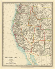
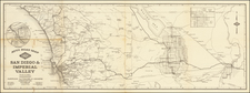
Rare map of California & Nevada by Charles Drayton Gibbes, which has been annotated by an early traveller, noting his travels to the mining regions in California and Nevada.
Charles Gibbes first issued his large format map of California and Nevada in 1869. This map is without question one of the best and most detailed maps of the region, winning high praise from Wheat, Rumsey and other commentators for its unparalleled detail, accuracy and compilation of the most recent information. There are many details which appear on this map which do not appear on other printed maps of the period.
The present example shows the travels of a contemporary user of the map throughout the region. It would appear that the original owner travelled by sea to San Franscisco and then on northward, and also travelled overland from Oregon to California, through the California gold regions and Southern California and on the Washoe and White Plans Mining regions, with numerous side trips. The annotations reflect 3 different districts, with the towns note below underlined:
District 1: Aurora, Washington, Glendale, Genoa, Hot Springs, Van Sickles
District 2: Ward, Hamilton, Eureka
District 3: Darwin, Cannon, Telescopi, Death Valley,
Palisades in Humboldt County
In Nevada County: Summit, Emirgrant
While we have not been able to identify the mapmaker, the annotation of the map into what appears to be further color coded mining regions suggests some sort of scientific expedition, likely undertaken in 1878, since the map was updated the following year.
We note that in 1878, Gibbes seems to have updated this map (on a scale of 1 inch to 18 miles). Accordingly, this edition almost certainly reflects the most complete version of the map. While no comprehesive study of Gibbe's maps has been undertaken, this appears to be the third of Gibbe's large format maps, following the 1869 edition (re-issued in 1876, 1879, 1881, 1882) and a reduced size 1873 edition (which was revised in 1875, 1876 and 1878) and this third edition of 1878 (which appears to have been reissued in 1879, 1881 and 1882). This third edition includes the inset profile "Elevation Above The Sea Of Some Of The Principal Mountains In California And Nevada," which appears on large 1869 edition, but not the reduced size 1873 edition.
The full title of the map is
Map of the States Of California And Nevada. Carefully Compiled from the Latest Authentic Sources. California By By Chas. Drayton Gibbes C.E. Comprising Information obtained from the U.S. Coast And Land Surveys; State Geological Surveys, By Prof. J.D. Whitney; Railroad Surveys And The Results Of Explorations Made By Brevet Lieut. Col. R.S. Williamson, U.S.A., Henry DeGroot, C.D. Gibbes, And Others. Published by Warren Holt. No. 717 Montgomery Street, San Francisco, Cal. 1878.
After a distinguished career as a mapmaker and civil engineer in California, Gibbes (1813-1893) became curator of mineralogy at the California Academy of Sciences, San Francisco, following which he retired on a small pension. As Wheat notes, he left "a record of long-continued and important scientific service in his adopted state."
![[ Republic of Texas ] Central America II. Including Texas, California and the Northern States of Mexico](https://storage.googleapis.com/raremaps/img/small/93534.jpg)