|
||

|

|
|

|
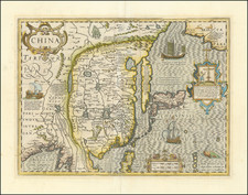
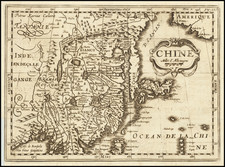
Important Early Map of China, Based Upon Jesuit Sources.
Sanson's scarce map of China and Korea. This is one of the earliest maps to incorporate the geographical information brought back to Europe by the Jesuit Missionary Martino Martini, who is widely regarded as the father of Chinese geographical science. The map first appeared in the 1658 edition of Sanson's Cartes Generales de Toutes les Parties du Monde.
Martini was the first to study the history and geography of China with rigorous scientific objectivity. The extend of his knowledge of the Chinese culture, the accuracy of his investigations, the depth of his understanding of things Chinese are examples for modern sinologists. Ferdinand von Richthofen calls Martini "the leading geographer of the Chinese mission, one who was unexcelled and hardly equaled, during the XVIII century…There was no other missionary, either before or after, who made such diligent use of his time in acquiring information about the country".
Sanson also credits the 16th-century Jesuit missionaries Matteo Ricci and Michele Ruggieri in the text section of the cartouche.
The map extends to include the northern tip of the Philippines and a curiously curved Korean peninsula. Korea was usually shown as an island until the middle of the 17th century, so Sanson's depiction is a significant cartographic improvement. The Great Wall forms the northern boundary of China and the map is filled with rivers, mountains, and villages.
A detailed explanation panel in the bottom right is surmounted by Pheme, the personification of fame and renown. The text translates as follows:
This Map is but a summary of another very beautiful, very large, and very particular one; which is in the Cabinet of H.R.H. the Duke of Orleans: where Matheo Neroni, its Author, assures that it was drawn in Rome in 1590, and drawn from four different books, printed in China; and of which Father Michel Ruggieri, a Jesuit, gave the explanation to this Neroni. I was not able to include in this summary the cities of the first and second rank; not having had enough space for everything else. That this summary being engraved I had the China of Father Martinius, and saw something of that which Father Bouyn wants to publish, and which he believes to be the best of all. The China of Father Martinius is in sixteen different maps, for as many provinces; but which are not more extensive, sometimes less than that of Neroni: and when I wanted to compare these Maps with each other, I found a very great difference, both in the names and in the numbers of the Fu, which are the largest cities, and the Ceu which are the second; even more in everything else either for the plan of the Map or for the position of the places. This makes me believe that these Maps are drawn from various Authors of the Country [China], and that it will be difficult to judge the best. We will say something when we have the opportunity.
Nicholas Sanson (1600-1667) is considered the father of French cartography in its golden age from the mid-seventeenth century to the mid-eighteenth. Over the course of his career he produced over 300 maps; they are known for their clean style and extensive research. Sanson was largely responsible for beginning the shift of cartographic production and excellence from Amsterdam to Paris in the later-seventeenth century.
Sanson was born in Abbeville in Picardy. He made his first map at age twenty, a wall map of ancient Gaul. Upon moving to Paris, he gained the attention of Cardinal Richelieu, who made an introduction of Sanson to King Louis XIII. This led to Sanson's tutoring of the king and the granting of the title ingenieur-geographe du roi.
His success can be chalked up to his geographic and research skills, but also to his partnership with Pierre Mariette. Early in his career, Sanson worked primarily with the publisher Melchior Tavernier. Mariette purchased Tavernier’s business in 1644. Sanson worked with Mariette until 1657, when the latter died. Mariette’s son, also Pierre, helped to publish the Cartes générales de toutes les parties du monde (1658), Sanson' atlas and the first French world atlas.