


|
||

|

|
|

|
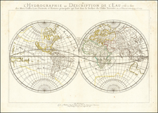
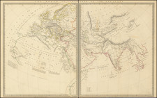
One of the earliest of Sanson's world maps and one of the earliest obtainable maps to show the five Great Lakes. The map is based upon Sanson's 1651 map of the world (Shirley 390), but with more prominence given to marine and river features. California is shown as an island.
In this map Sanson has renamed Nouvelle Albion in the northwest part of North America as Terra de Iesso and the Detriot d'Anian has been moved to just north of California. Australia is only partially shown, still marked Beach (after Marco Polo), and there is a faint outline of the southern continent labeled Terre Australe Magellanique & Incogneue. The curious massive land mass which nearly connected Asia and the northwest coast of America is also shown in a faint outline, which is very different than illustrated in Shirley 390. There is no known explanation for this landmass, which extends to Niphon and would nearly double the size of the usual landmass shown in this area on Sanson's other world maps.
Nicholas Sanson (1600-1667) is considered the father of French cartography in its golden age from the mid-seventeenth century to the mid-eighteenth. Over the course of his career he produced over 300 maps; they are known for their clean style and extensive research. Sanson was largely responsible for beginning the shift of cartographic production and excellence from Amsterdam to Paris in the later-seventeenth century.
Sanson was born in Abbeville in Picardy. He made his first map at age twenty, a wall map of ancient Gaul. Upon moving to Paris, he gained the attention of Cardinal Richelieu, who made an introduction of Sanson to King Louis XIII. This led to Sanson's tutoring of the king and the granting of the title ingenieur-geographe du roi.
His success can be chalked up to his geographic and research skills, but also to his partnership with Pierre Mariette. Early in his career, Sanson worked primarily with the publisher Melchior Tavernier. Mariette purchased Tavernier’s business in 1644. Sanson worked with Mariette until 1657, when the latter died. Mariette’s son, also Pierre, helped to publish the Cartes générales de toutes les parties du monde (1658), Sanson' atlas and the first French world atlas.
![[Illuminated World Map -- There is no region of the world which Jesus, like the sun, does not enrich...] Orbis nulla plaga est quam sol non ditet Iesus...](https://storage.googleapis.com/raremaps/img/small/62347.jpg)