|
||

|

|
|

|
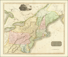
A New York Rarity
An extremely rare map documenting the scramble for land in post-Revolutionary New York State, with interesting manuscript additions by an early owner.
Covering a significant portion of the Finger Lakes region of New York, the present map is one of the earliest printed maps to focus on the region and one of the rarest.
Overview
Among the biggest losers of the American Revolution were the Iroquois of central and western New York, most of whom had sided with the British in the hope of forestalling settlement on their lands. The ironic result was that after the war these lands became fair game for wealthy speculators-both American and European-eager to make a killing from sales to land-hungry New England farmers. By means of a maze of treaties and private deals, the region was carved up into enormous tracts, one of which was the so-called Phelps and Gorham Purchase of 1788.
The Phelps and Gorham Purchase had its roots in the 1786 Treaty of Hartford, which resolved a dispute between Massachusetts and New York over the former's claim to some six million acres west of Seneca Lake. As a result of the Treaty, Massachusetts ceded sovereignty over the area, but retained the so-called "pre-emptive" right to negotiate with the Iroquois for title to those lands, or to profit by selling that right to a third party. Two years later, a consortium led by Oliver Phelps (1721-1821) and Nathaniel Gorham (1738-1796) purchased this right for $1,000,000, payable in depreciated Massachusetts scrip in three annual installments. Both men were successful Massachusetts businessmen and politicians, and Gorham had also been a delegate to the Constitutional Convention in Philadelphia.
In July 1788, Phelps met with Iroquois representatives at Buffalo Creek in an attempt to negotiate to obtain clear title for the entire parcel. He was able to acquire title only to the lands east of the Genesee River, plus a parcel on the west bank of the Genesee abutting Lake Ontario, some two million acres in all. The story behind the parcel along the Genesee, known as the "Mill Yard Tract," is interesting. As a negotiating point, Phelps suggested that the Iroquois would benefit from a grist mill on the west bank of the river. When the Iroquois asked how much land would be needed, he cheekily suggested that a huge piece of land running 12 miles west of the river and 24 miles south of Lake Ontario would suffice! Despite its patent absurdity the ploy worked, Phelps gained the Mill Yard Tract, and grist and saw mills were eventually built at the Falls of the Genesee.
Within a year of the Buffalo Creek council, the value of Massachusetts currency rose sharply in anticipation of Hamilton's plan to nationalize state debts, thereby increasing the cost of the Purchase. This, combined with insufficient land sales, forced Gorham and Phelps to miss a payment to Massachusetts, for which they forfeited much of "their" lands west of the Genesee back to the state (Recall, they had been unable to negotiate title to these lands from the Iroquois.) In 1791, Massachusetts sold this western parcel to financier Robert Morris of Philadelphia, who in turn sold it off to British and Dutch consortia at a huge profit. After missing another payment, Gorham and Phelps sold all remaining unsold lands east of the Genesee directly to Morris, who then in 1792 sold it to a British consortium known as the Pulteney Association, making a huge profit on the transaction.
The Map
Offered here is a very rare map depicting the tract to which Gorham & Phelps were able to gain title from the Iroquois. While not nearly as large as what they had sought, it was still vast, bounded by Lake Ontario to the north, the Genesee River to the west (with the exception of the Mill Yard Tract along the opposite bank), Pennsylvania to the south, and the so-called Old and New "Preemption Line" to the east (this was the line negotiated by Massachusetts and New York in the Treaty of Hartford. "Old" and "New" versions of the line are shown because the original survey of 1788 was grossly inaccurate and had to be repeated in 1791-92.)
Just to the east of the Preemption Line are the New York Military Lands, which had been set aside for the compensation of the state's Revolutionary War veterans. The familiar grid of ranges and townships is clearly visible if haphazard, roads are indicated, and a variety of symbols indicate towns and settlements, grist mills, and saw mills (including those in the aforementioned Mill Yard Tract). At some early date an unnamed owner extensively annotated the southern half of the map with dotted lines indicating trails, as well as information about distances, landowners &c.
The Mapmaker--Augustus Porter
The map was drawn by Augustus Porter (1769-1849), a native of Salisbury, Connecticut who worked as a surveyor in western New York in the 1790s before moving to the Niagara Falls area. He had been involved in both the original survey of the Gorham & Phelps Purchase in 1788 as well as the re-survey in 1791-92, which took place after the sales to Robert Morris. His map is undated, but Phillips and Wheat & Brun suggest it was issued in 1794, while Evans gives a date of 1795.
Rarity
The map is extremely rare. We find no record of another example having appeared on the market in the past 100 years. The only record we could find was in The Important Collection of Americana from the Library of W.H. Samson, held by The Anderson Auction Company on December 12 and 13, 1911, lot 446, where the catalog noted that the Samson had purchased the map for $40.00 and that the map was: "An Excessively Rare Map . . . I never knew of another copy being offered for sale."
Impressions are held by the Canandaigua Historical Society, Clements Library, Library of Congress, New York Historical Society, New York Public Library, University of Wisconsin-Madison and Yale.

![[Niagara Falls] Cataracte de Niagara](https://storage.googleapis.com/raremaps/img/small/96890.jpg)