


|
||

|

|
|

|
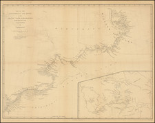
Rare Promotional Map of Central British Columbia
Fine large promotional map of a section of British Columbia, published by the Grand Trunk Pacific Railway.
The map illustrates the routes of the Railroad beginning in the Prince Ruppert area and extending eastward to Jasper and the Jasper National Park area.
The fine prospects for agriculture, cattle (Grazing lands), gold mining, big game hunting are noted along the way, with regular train stops and towns located all along the route.
The dashed lines illustrate water routes via the Grand Trunk Steamship Line to various points in the region and on Queen Charlotte Island, with overland trails to important mining and other regions in the north marked in light red.
An interesting and rare early promotional map for the central regions of British Columbia, an area which was rarely covered by maps of this period.
Rarity
The map is apparently quite rare. We locate only the example in the Toronto Public Library.
![The Coast of Newfoundland From Plancentia to Cape Bonavista [and] A Draught of the River Plata in South America [and] Havana, Harbour [and] the Bay of Honda](https://storage.googleapis.com/raremaps/img/small/38599.jpg)