


|
||

|

|
|

|
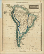
First State of One of the Most Important Sixteenth-Century Maps of the Americas and the Pacific
This is of only a few surviving examples of the Venetian mapmaker Giovanni Battista Mazza's separately issued Lafreri School map of the Americas and the Pacific, published by Donato Roscicotti. Mazza's map is particularly noteworthy for three reasons:
- First map to show a recognizable portrayal of the Outer Banks of the Carolinas
- First map to correctly name the island of Roanoke, Virginia (founded in 1587)
- First map to specifically mention an English settlement in North America
For many years Mazza's map has been part of a fascinating debate as to its sources and its relationship to two of the most iconic maps of the Americas, Abraham Ortelius's Americae Sive Novi Orbis Nova Descriptio (1587) and his Maris Pacifici (1589), the first printed map of the Pacific.
Little is known about Mazza beyond his Venetian roots. The publisher, Donato Rascicotti, was an active part of the Lafreri School of map publishers. He was originally from Brescia but worked from a shop on the Ponte dei Baretteri in Venice. They worked together on other maps; this map was part of a set of four of the continents. All are extremely rare.
The Hogenberg, Mazza, Ortelius Sequence
The present map belongs to a group of four highly influential maps of the Americas and the Pacific published between 1587 and 1590, a time of significant advances in the mapping of the Americas. The others are the previously mentioned Abraham Ortelius's Americae, his Maris Pacifici, and Frans Hogenberg's Americae Proximarum Regionum Orae Descriptio.
For many years, the relationship between these four maps has been the subject of study by a number of commentators. It is accepted that the highly influential Ortelius Americae, published in 1587, preceded the other three and served in part as the prototype map for the later maps by Mazza and Hogenberg. Each of these two maps, however, incorporated important new information not present in the Ortelius map of America and also expanded the coverage of the Pacific further westward in order to incorporate Japan and eastern China, thereby showing most of the Pacific. Shortly thereafter, almost certainly inspired by one or both of the Mazza and Hogenberg maps, Ortelius created his own new map. Maris Pacifici would push a bit further west and frame the Pacific exclusively, therefore becoming what is now regarded as the first printed map of the Pacific Ocean.
For many years, it was unknown whether the Maris Pacifici preceded the Hogenberg and Mazza maps. The most recent study of the map appeared in the Map Collector in the spring of 1995, where Richard Casten and Thomas Suarez reached the conclusion that the Hogenberg was the first of the three maps, followed by the Mazza and finally the Maris Pacifici.
The evolution of the three maps is truly fascinating. The Hogenberg map takes the Ortelius Americae prototype and pushes it further west, to approximately 170 degrees east latitude, showing a portion of the coastline of China. Mazza's map extends even further west, with additional details in China including, most notably, the Great Wall of China. Finally, the Ortelius Maris Pacifici pushes another ten degrees to the west.
One feature which has been largely overlooked, and which we attempt to address below, is that the Mazza map is by far the most geographically innovative of the maps noted above, including extensive annotations not present on the Ortelius and Hogenberg maps, more topographical details, and additional place names.
Examples of the more nuanced cartographic detail in the Mazza include the naming of Bergi R. and Agama in the extreme northwest of America, both of which would seem to be drawn from Guillaume Postel's world map of 1582. Similarly, the annotations in the Mazza map are drawn from a number of important sources including Richard Hakluyt and manuscript maps. It remains a mystery as to how Mazza gained access to some of them from Venice.
Noteworthy Cartography: Virginia, Roanoke, and the Colonization of the East Coast of America
The Mazza map is of great note for its cartographic content in Virginia. It is the first map to name and locate Roanoke ( Roanoae) Island. He shifted the name Virginia to the mainland. By contrast, the Hogenberg map had named Virginia, but placed it as an island well east of the mainland. This is the first time the name of the island was correctly included and is therefore the first specific reference to an English settlement in North America.
The land that would become known as Virginia first came to European notice after the 1524 voyage of Giovanni Verrazano, who was sailing on behalf of the King of France. Verrazano encountered land at roughly 34°N and continued to sail north around what is now known as the Outer Banks until he reached an abundant land he called Arcadia.
Eager to join the ranks of overseas empires, England supported colonizing missions in the late sixteenth century, including the schemes of Sir Walter Raleigh. In 1584, Raleigh sent Philip Amadas and Arthur Barlowe to find a suitable location for settlement. They landed in what is now North Carolina and made contact with local indigenous peoples. In response to their query as to the place's name, they were told "Wingandekoa", which actually means "You have fine clothes"; clearly communication was difficult. Wingandekoa is the toponym selected by Ortelius for his 1587 Americae, a precursor to the Mazza map. Ortelius' 1587 map is also considered one of the first to show Chesapeake Bay.
In the same year, a map dedicated to Richard Hakluyt became the first map to use the name "Virginia". Hakluyt was an ardent supporter of English expansion and he advocated for further efforts to settle in North America. To this end, Hakluyt translated and compiled documents about the travels and voyages of his and other countries, most famously in his Principall Navigations (1589, 1598). The 1587 map, which accompanied Hakluyt's annotated edition of Peter Martyr's De Orbe Novo, places "Virginea 1584" between Florida and Nova Francia-a bold claim for sovereignty tucked between the opposing Spanish and French claims. It seems that Mazza consulted the Hakluyt, particularly on the Virginia issue, but the overall geography of Mazza's map is closer to Ortelius and Hogenberg, particularly in the northern parts of North America and with regard to the southern continent.
In 1585, Raleigh had sent an advance party to scout for a place for a settlement on the North American coast. They eventually settled on Roanoke Island. In the initial party was Thomas Hariot, mathematical genius, and John White, artist turned governor of the colony. Both men left hoping the colony would flourish. It did not and the subsequent disappearance of the colonists is one of history's great mysteries.
However, Hariot and White did go on to share their impressions of the land and its peoples, including a detailed map, published by Theodore de Bry in 1590. A year before, as previously stated, Mazza had made his map with Roanoae gracing an island off the Atlantic coast. Mazza included the symbol for a settlement on the island. Inland and slightly to the south is Virginia, labeled correctly on the mainland. Mazza's map was the first to include the topoynms correctly on island and mainland and are the first cartographic confirmation of the English expansion so desired by Raleigh and Hakluyt.
Mazza's map also gives a remarkable early accounting of the Outer Banks, suggesting that Mazza had access to the manuscript maps brought back to England circa 1585 from the Roanoke expeditions. While Casten and Suarez have suggested that the map was constructed by Mazza from written accounts, the quality of the depiction of the Outer Banks suggests that a manuscript map may have been available to Mazza.
A second state of the Hogenberg, revised and updated to include Roanoke, would appear some years later. The second state also moved Virginia onto the mainland and incorporated the chain of islands shown by Mazza along the east coast of North America, likely reflective of a primitive knowledge of the Outer Banks and perhaps the Chesapeake.
Noteworthy Cartography: South America
On Mazza's map, the large bump in the west side of South America has been removed, following Hogenberg's map and the revised edition of Ortelius's Americae. Brandmair asserted that the bump was first removed by Ortelius because of Mazza's map, which Brandmair incorrectly dated to 1583. As discussed, Casten and Suarez reversed that chronology.
Mazza's map is also far more detailed in the interior parts of South America, with significantly more place names and topographical features than Ortelius or Hogenberg. There is also an extensive note below the Rio de la Plata crediting its discovery to Amerigo Vespucci in 1501 (third voyage). Smaller vignettes and annotations on the map note Columbus's Guanima and the discovery of the West Coast of North America by the Spanish in 1542, annotations which are not incorporated on the maps of Hogenberg and Ortelius.
Noteworthy Cartography: the Pacific
The Pacific as shown in this map may appear fantastic to the modern reader, but it would have also been remarkable to viewers in the late sixteenth century. A close study of the Ortelius, Hogenberg and Mazza maps shows that the Mazza is the most comprehensive, including better cartographic details and more extensive annotations.
New Guinea is large, but dwarfed when compared to the huge southern continent that lines the bottom of the map. Magellan's ship Victoria is prominent in the sea off South America, although not nearly as prominent as in Ortelius' Maris Pacifici. Also divergent from Ortelius' Pacific is the ' Streto de Anian' marked here as running toward the North Pole along what is now known as the Alaska shoreline. Anian derives from Ania, a Chinese province mentioned in Marco Polo's travels. The Strait bearing that name was shorthand for a passage to China, i.e. a Northwest Passage.
Oretlius Maris Pacifici is widely accepted as the first printed map of the Pacific Ocean. While it is true that the Maris Pacifici is the first map to use the ocean's name so explicitly in the title and centers upon the ocean to the exclusion of parts of the American continents, it should be noted that both the Hogenberg and Mazza maps cover the entire ocean from North and South America west to Japan and New Guinea in detail previously unseen. In that sense, Mazza's portrayal of the Pacific is the second map to cover such an area in such detail.
States
Burden's two states of the map:
State 1: Lower left: "Venetiis Donati Rascicotti formis." / "Gio. Bat. Mazza fece."
State 2: The Rascicotti and Mazza imprints are erased but barely visible.
The present map is an example of the first state.
Rarity
This is a previously unknown example of the first state. According to Burden, only five examples of the first state are known, although the location of one is indefinite: Royal Library (Den Hagg), the University of Leiden, two in private collections, and the W. Ashburner Lafreri Atlas, Florence (current location unverified). As the list shows, only one is in an American institution, at the University of Texas, Austin, which was acquired when the school purchased the majority of H. P. Kraus' stunning 1969 catalog, Monumenta Cartographica. He asked $1,250 for the first state of the Mazza at that time.
This is the first time we have handled either state of the map.
William C. Wooldridge, Mapping Virginia from the Age of Exploration to the Civil War (Charlottesville: University of Virginia Press, 2012).
![[Sea of the West] L'Amerique divisee Par Grands Etats . . . 1762](https://storage.googleapis.com/raremaps/img/small/98770.jpg)

![[English Edition!] Maris Pacifici quod vulgo Mar del Zud](https://storage.googleapis.com/raremaps/img/small/71000.jpg)
![America noviter delineata [ Heightened with Gold Leaf ]](https://storage.googleapis.com/raremaps/img/small/71040.jpg)