|
||

|

|
|

|
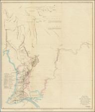
Southeast Asia with an Early Depiction of Northwestern Australia Based on Gerrit Frederikszoon de Witt's Discoveries in 1628
Scarce decorative map of Southeast Asia, China, India, the Philippines and western Oceana, along with the newly discovered regions in the northern parts of Australia, based upon Blaeu's map of the same period.
In addition to the Australian Coastline, the map provides fine early detail throughout the map, although the landmasses are considerably enlarged in scale, relative to their actual sizes, making for easy reading, but a definite skew in the amount of land, relative to the neighboring seas.
1628 Discoveries In Western Australia .
The map is among the earliest to show the discoveries along the northwest coastline of Australia by the Dutch ship Vyanen in 1628. The Vyanen departed Texel bound for Jakarta in March 1627, arriving via the Cape of Good hope on October 8, 1627. On January 6, 1628, the ship departed Jakarta as part of a fleet of seven ships bound for Europe under the command of the outgoing Governor-General of the Dutch East Indies Pieter de Carpentier. Just as the fleet was leaving, however, a valuable cargo arrived from China, so the Vyanen was held back to be loaded. She was then sent to catch up with the main fleet, but had been loaded too hastily, and had to return to port to have her load balanced by the addition of 5000 ingots of copper.
When the Vyanen finally departed again on January 20, 1628, the monsoon season had set in, preventing her from taking the usual route through the Sunda Strait. Instead, the captain, Gerrit Frederikszoon de Witt, was ordered to set a course through the Strait of Balamban. Strong head winds then drove the ship so far south that she ran aground in the vicinity of Barrow Island on the northwest coast of Australia. By offloading cargo de Witt succeeded in freeing the ship. He then followed the coast south-westwards as far as the Montebello Islands, Barrow Island and the coastal reefs to the south. His sighting of the coast to the east of the Montebello Islands was a new discovery.
Hessel Gerritsz' map of 1628 shows the discovery under the name 'G.F. de Wits Landt'. On returning north, de Witt charted the northwest coast about as far as the present-day location of Port Hedland. The crew also sighted Indigenous Australians in the vicinity of present-day Roebourne; this is believed to be the first European sighting of Indigenous Australians in Western Australia.
The map also shows the earlier discoveries in this region by Dirk Hartog in 1616. Hartog located the area of Shark Bay and became the first European to set foot on Western Australia when he landed on what is now known as Dirk Hartog Island. He thereafter explored the coastline to the north along the coast of what is called T Landt Van Deendracht on Merian's map.
Farther to the northwest, the Dutch discoveries along the North West Cape and the Gulf of Carpenteria are shown.
Mathaus Merian (1593-1650) was the father of engraver Matthäus the Younger, and of the painter, engraver, and naturalist Maria Sibylla Merian. He was born in Basel, Switzerland and trained in engraving in Zurich. After a time in Nancy, Paris and Strasbourg, he settled in Frankfurt. While there, he worked for Johann Theodor de Bry, the publisher and son of the travel writer. In 1617, he married Maria Magdalena de Bry, Johann Theodor’s daughter. In 1623, Merian took over the de Bry publishing house upon the death of his father-in-law. Merian’s best known works are detailed town views which, due to their accuracy and artistry, form a valuable record of European urban life in the first half of the sixteenth century
![[ Hindus - Fire worshipers from outskirts of Baku ] Indiens (Habitants de Bakou, adonnes au culte du feu) Индусы Огнепоклонники изъ окрестностей баку)](https://storage.googleapis.com/raremaps/img/small/86593.jpg)
![[Northwestern India & Pakistan] Tabula Asiae IX](https://storage.googleapis.com/raremaps/img/small/46402.jpg)