


|
||

|

|
|

|
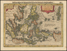
Rare Sea Chart of Australia, Southeast Asia and the Eastern Indian Ocean
Rare early sea chart of Australia, the Indian Ocean and contiguous regions from China and Southeast Asia, published by the Johannes Van Loon.
The charts illustrate the Dutch sphere of influence in Southeast Asia and Australia. The charts include details of the Dutch discoveries in Australia of Hartog (1616); Houtman (1619); the Leeuwin (1622) and Carstenszoon (1623); as well as de Wits (1628); and Tasmans second voyage in 1644 (Northern Australia) and Peter Nuyts exploits (1627).
Van Loons chart is in turn based on Hendrik Doncker's sea chart of 1659, although the map is now oriented such that the map extends a bit further to the South and West.
Rarity
The chart is very rare on the market. We know of no example of the map offered in more than 30 years. Our research suggests that there are only a few surviving examples.
![Calcutta & Howrah Guide Map [with] Calcutta & Howrah Guide Map (1st Edition 1933) Alphabetical Index to Names. Tape Indicator Issue.](https://storage.googleapis.com/raremaps/img/small/101270.jpg)
![[ Indian Ocean - Sailing to Batavia ] Route Exacte De Gamron a Batavia et de Batavia a Gamron](https://storage.googleapis.com/raremaps/img/small/44380.jpg)