|
||

|

|
|

|
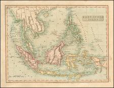
An Early Look at New Guinea and the Solomons
Nice example of this early state of Barent Langenes’ map of New Guinea and the Salomon Islands which first appeared in the 1598 edition of Langenes’ Caert-Thresoor, published in Middelburg.
The present map is one of the earliest obtainable maps of the region.
The map features part of the northern coast of New Guinea. To the east are the Solomons, which had been recently visited when this map was published.
Portuguese and Spanish navigators were the first Europeans to encounter New Guinea. They would have sailed nearby in their search for spices in the East Indies. In 1526-6, the Portuguese Jorge de Menezes visited the main island and supposedly named in Papua. A Spaniard, Yñigo Ortiz de Retez, called in New Guinea in 1545; he thought the peoples resembled those from Guinea in Africa. Aside from these superficial encounters, however, Europeans did not penetrate beyond the coasts and did not know the extent of the islands until the late-eighteenth and early-nineteenth centuries.
Alvaro de Mendaña was sent to the western Pacific in search of the so-called “Isles of Fortune” rumored to have been visited by the Inca hero Tupac Yupanqui. Mendaña left Callao, Peru in 1567 and landed on the Solomons and islands farther east (Isabella). However, the crew encountered cannibals and they returned to Peru. At the end of the seventeenth century, Mendaña returned to the Pacific to search for the Solomons but contacted the Marquesas instead. The Solomons, whose longitude was not correctly recorded, would wander the Pacific on maps until the late eighteenth century.
Langenes's map was first issued in Caert-Thresoor (1598), a miniature atlas. While it was prepared by Cornelis Claesz and engraved by Jodocus Hondius and Pieter van den Keere, the book was published by Langenes in Middelburg, who worked as a collaborator in publishing this large project.
Beginning in 1600, the map was re-published by Bertius in his Tabularum Geographicarum. The map was used a dozen times in works by the two between 1598 and 1650.
Barent Langenes was a Dutch publisher and engraver at the turn of the seventeenth century. He worked in Middleburg, Netherlands. He is best known for his publication of Petrus Bertius’ Caert-Thresoor in 1598. This pocket world atlas was small, printed in the vernacular, and was more affordable than folio-sized competitors, allowing more people to own and use atlases. The atlas was a commercial success and was printed twelve times in Dutch, French, Latin, and German editions between 1598 and 1650, although Langenes was most likely only involved in the first two Dutch editions (1598 and 1599).
![Asie No. 110. Partie De Camboge [Vietnam]](https://storage.googleapis.com/raremaps/img/small/0206gh.jpg)