|
||

|

|
|

|
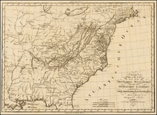
Rare Dutch Edition of Bellin's Controversial and Highly Important Map Illustrating the French and British Historical Claims to the Canadian Maritimes and Maine, published in Paris on the Eve of the Seven Years' War (1756-63)
Rare Amsterdam imprint Bellin's Carte d'une partie de l'Amérique Septentrionale pour servir á l'intelligence du mémoire, delineating the boundary dispute between France and England over Nova Scotia and illustrating historical French claims in Acadia, along with an Italian translation of the original French text that accompanied the original.
The map focuses on the Canadian Maritimes, but extends west to Lake Erie and south to the Roanoke River.
Eight various and dueling British and French claims to parts of the Canadian Maritimes (Acadia), Quebec, and Maine, are shown to divide up the territory in various ways, employing lines and shading, as explained by a key in a cartouche in the bottom right.
A note in a second cartouche in the interior of North America explains that the place names Canada and New France are not included, as their location is precisely what is being decided. This map is an excellent example of how maps can help to define space and change history.
Acadia
The toponym Acadia supposedly comes from the geographer Giovanni da Verrazzano, who used the term to refer to the whole of North America north of Virginia in a sixteenth century map. Although several European vessels contacted the region, which was populated by Mi'kmaq people, the first European settlement began in 1604. A year later, they relocated across the Bay of Fundy and established Port Royal.
Over the course of the seventeenth century, there were six colonial wars over control of the territory. For example, in 1654, a fleet under Robert Sedgwick captured Port Royal, the main settlement, in the name of Oliver Cromwell, which began thirteen years of English. In 1710, the British blockaded Port Royal and in the Treaty of Utrecht were granted control of the area. However, the precise region specified in the treaty was unclear, which led to the boundary dispute this map illustrates.
The Acadia Boundary Dispute
In 1749, Britain and France formed a Joint Commission to resolve their boundary dispute in Acadia. Tensions between the two powers remained high following the signing of the Treaty of Aix-la-Chapelle (1748), which ended the War of Austrian Succession (1740-8) on the terms of the status quo ante bellum, that is, a return to the boundaries before the war. However, France and Britain disagreed about what the status quo ante bellum meant.
As mentioned, the previous boundaries were last prescribed by the Treaty of Utrecht (1713) and the wording describing the boundaries was extremely vague. While both sides agreed that France had ceded at least part of Acadia to Britain in 1713, they could not agree on the size and extent of the ceded territory. The original wording of the Treaty of Utrecht read:
The most Christian king [Louis XIV of France] will entrust to [Anne] the Queen of Great Britain… Nova Scotia also, otherwise Acadia, in its entirety, conformable to its ancient limits; as also the town of Port Royal, now called Annapolis Royal, and generally all the dependencies of the said lands…
The British interpreted this to mean that France had ceded to them all of the Canadian Maritimes, Quebec's Gaspé Peninsula, and a piece of the south shore of the St. Lawrence River. The French interpreted the same agreement to mean that they had only ceded the south coast of the Peninsula of Nova Scotia and the vicinity of the town of Port Royal (renamed Annapolis Royal by the British in 1713). More recent legal analysis has supported the interpretation that the cession should have actually consisted of the entirely of Peninsular Nova Scotia, but nothing else. As the present map shows, both sides were entrenched in their own views.
As discussed by Mary Pedley in her fine article "Map Wars: The Role of Maps in the Nova Scotia/Acadia Boundary Disputes of 1750," both sides on the Joint Commission employed a great assortment of historical maps and written records to prove the primacy of their respective claims. The French were represented by the Marquis de la Galissonière, former commandant of New France and a naval officer employed at the Dépôt des cartes et plans de la Marine, and Étienne de Silhouette, an economic theorist and civil servant. The British chose William Shirley, a governor of Massachusetts interested in mapping, and William Mildmay. Shirley was dismissed in 1752 and replaced by Ruvigne de Cosne, first secretary to the British Embassy in France. The men met from 1750 to 1753, trying to make sense of the various claims.
Both sides marshalled strong historical precedents to shore up their arguments. The British claimed that the region was discovered by John Cabot, an explorer sailing under the English flag in 1497, and that King James had formally chartered the territory to British (then Scottish) subjects in 1621. The French, not to outdone, countered that they had built the first permanent settlement in the region (Port Royal), which was followed by numerous French royal charters, settlements, and fortifications, most notably the great bastion of Louisbourg on Cape Breton Island. In effect, they argued that no matter who might have encountered the land first, they had invested and settled it more thoroughly and effectively. The English then counterclaimed that this was all trumped by the more recent Utrecht cessions and that British claims were now anchored by the large Royal Navy base at Halifax (founded in 1749).
The Seven Years' War and the continuing influence of the map
Not surprisingly, in spite of the detailed deliberations and unprecedented investigation of historical cartography, the Joint Commission was deadlocked; it disbanded in 1754 and was replaced by direct diplomacy. To further make their case, British mapmaker Thomas Jefferys published A New Map of Nova Scotia, and Cape Breton Island… (London, 1755) which showed the extent of their claims. The French provided this map, likely devised by Jacques-Nicolas Bellin, which sought to lay out the historical claims and favorably compare the French claims to the British contentions.
The various boundaries marked on the map are described as follows:
- The boundaries proposed by the Memoranda of the English Commissioners dated September 21, 1750 and January 11, 1751… (This line defines Britain's brazenly ambitious claim as presented to the Joint Commission, which held that all of the territory east and south of a line running along the south shore of the St. Lawrence River near Quebec, and then running down directly southwards to the Gulf of Maine to a point just west of the Kennebec River, belongs to Britain).
- The boundaries of Acadia and the adjacent sea banks as specified by the Treaty of Utrecht… (This line defines the minimalistic and frankly inaccurate French interpretation of their cession to Britain during the Treaty of Utrecht. In reality, France ceded all of Peninsular Nova Scotia to Britain, although here this cession shows that the French only ceded the south coast of the peninsula).
- The Vicinity of Port Royal which was ceded in the Treaty of Utrecht… (The line cordons off the area of southwestern Peninsular Nova Scotia that surrounds the town of Port Royal (Annapolis Royal), which here is noted as an additional French cession to Britain under the Treaty of Utrecht).
- The Limits of Nova Scotia following the Concession of James I to William [Alexander] in September 1621… (This line defines the limits of the massive grant that James I charted to the Scottish courtier William Alexander in 1621. Alexander named the grant 'Nova Scotia', so giving that name to the region for the first time. This grant included all of the Canadian Maritimes, being east of a line running from the St. Lawrence Estuary near Baie de Bic down to Passamaquoddy Bay).
- The lands conceded by [Oliver] Cromwell to Messrs. La Tour, Crown and Temple on August 9, 1656… (The region is an ovoid area embracing the shores of the Bay of Fundy and a part of eastern Maine, as defined by a double fine line. This land claim relates to an extremely bizarre sequence of events. Charles de Saint-Étienne de la Tour (1593-1666), who served as the Governor of French Acadia (1631-42 and 1653-57), was deposed by a rival colonial leader, the Sieur de Charnizay, in 1645. He then switched sides to the English, whereupon he received, in conjunction with two English subjects, this grant from Oliver Cromwell, then Lord Protector of England. De la Tour subsequently returned to French allegiance, supposedly invalidating Cromwell's award).
- The Government of Sieur Denis in 1654… (This area was granted by King Louis XIV to Nicolas Denys (1598-1688), a colonial adventurer who wrote an important early description and history of Acadia, Description géographique et historique des costes de l'Amérique septentrionale: avec l'histoire naturelle du païs (Paris, 1672).).
- The Government of Sieur Charnizai in 1638… (The area includes the region granted to Charles de Menou d'Aulnay, the Sieur de Charnizay (1604-1650), in 1638 by Louis XIII. Aulnay acted as the de facto Governor of French Acadia after deposing La Tour).
- The Government of Sieur La Tour in 1638… (This area encompasses the original grant given to the abovementioned Governor Charles de la Tour by Louis XIII in 1638).
While the Ohio Valley Dispute is better known as a cause of the French & Indian, or Seven Years', War, the Acadia Boundary Dispute was in some ways more important, as the region represented both the gateway to New France and guarded the sea routes from the thirteen colonies to Europe. Also, the banks off Nova Scotia yielded a great wealth in fisheries, revenues infinitely more sizable than those received from the Ohio Country. As the French Ambassador to Britain, the Marquis de Mirepoix, reported during the negotiations on the words of the Duke of Newcastle, Britain's chief diplomat, "as to the article for the Ohio, [Newcastle] repeated to me that it was much less important to them than that for Acadia" (as quoted in Lennox, 42).
The issue would have been a priority in both London and Paris as the two empires headed for war in 1755, the year that this map was printed. During the war, it was reprinted several times and in several languages. In the same year, 1755, the British captured Fort Beauséjour, which gave them control of the Chignecto area, an area heavily populated with settlers of French descent. The British worried the settlers would undermine their rule and remain loyal to France; the military governor of Nova Scotia decided to forcibly remove thousands of Acadians. The deportations lasted from 1755 to 1778 and spread Acadians across the Atlantic World.
After Montreal fell to the British in 1760, the future of Nova Scotia, the former Acadia, was decidedly British. Nova Scotia, and most of western Canada, was ceded to Britain in the Treaty of Paris in 1763. Many remaining Acadians, who did not wish to live under British rule, moved to Louisiana, forming the basis of the Cajun population.
This map not only influenced the Seven Years' War, but a version of the map, now held in the National Archives of the UK, was used as late as 1830 to help British Canada review its border with the United States. It shaped Canada as we know it, chronicled a violent history of colonial clashes, and defined borders that still exist today.
States and Rarity
McCorckle describes this as the second state of the map.