|
||

|

|
|

|
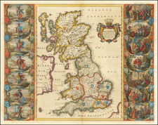
A Map Supporting James II, the Catholic king of England deposed in the Glorious Revolution of 1688
An exceptional and finely engraved map of the British Isles by Des Granges, and engraved by Roussel, in Paris, with a spectacular cartouche engraved by master engraver by Juan Dolivar (Jean Dolivar, 1641-1692), who signs in the cartouche "Dolivart inven et fecit" (Dolivar invented and made).
A separately issued French map of the British Isles, published in support of James II, the Catholic king of England deposed in the Glorious Revolution of 1688. Louis XIV of France had just declared war on England (The Nine Years' War), to restore James to his throne and break the Anglo-Dutch alliance created by William of Orange's accession to the British monarchy.
To the right of the title cartouche are portraits of James, his wife Mary of Modena and infant son James Francis Edward, later called 'The Old Pretender' or (by his supporters) James III. Top right is an inset map of the Faroes, Orkneys and Shetlands, with a list of British possessions abroad underneath; top right is a chart of the English Channel.
Des Granges was a French mapmaker at the end of the 17th century. His output was small, and only maps of Germany, Palestine and Greece by him, have been traced in addition to this one. The map carries the signature of Roussel, who engraved the map, and of Dolivart, who engraved the elaborate cartouche. The significance of the symbolic cartouche lies in the date 1689, the year in which Louis XIV declared war on England in support of the deposed Catholic monarch James II.
Insets of the Channel and of the Faeroe and Shetland Islands. Below the latter is a panel of text recounting the overseas possessions and forts of the English in America, the West Indies, Africa and Asia. -
Little is known about Des Granges: the Dictionary of Mapmaker lists his surname only, no personal dates, and, despite the appelation 'Géographe du Roy' on this map. Le mercure galant: 1689, beginning at page 182, gives a lengthy account of a fine set of maps which Des Granges had prepared for the King of France, specifically referencing him as Geographe du Roy.
Below the inset of the Shetland Islands is an inscription that reads:
Lieux Qui Reconnoissent La Couronne D'Angleterre. En Amerique, depuis le Cap Anna, jusques au Cap Henry, La Virginie, la nouvelle Yorch, la nouvelle Angleterre, la Bermude, aux Isles Antilles, la Barbade, Antigua, Mont Serrat Nieves, partie de St. Christophe, l'Anguille, Saba, la Barboude, la Iamaique, et une Colonie dans l'Isle de Terre Neuve, en Afrique, 2. Forts en Guinee, Tagrin et Cap Corse, Isle de Ste Helene, En Asie, au Coromondel Maderaspatan, l'Isle Bombain, et l'Isle Pouleran.
(Translation) Places That Recognize The Crown Of England. In America, from Cape Anna to Cape Henry, Virginia, New York, New England, Bermuda, the Caribbean islands, Barbados, Antigua, Mount Serrat, Neves, part of St. Christopher, Anguilla, Saba, Barbuda, Jamaica, and a colony on the Island of Newfoundland. 2. Forts in Guinea, Tagrin and Cap Corse, Isle of St Helene. In Asia, in Coromondel Maderaspatan, the Island of Bombay, And the Island of Pouleran.
A fascinating and historically important map.
![[ London & Westminster ] Midle-Sex described With The Most Famous Cities of London and Westminster](https://storage.googleapis.com/raremaps/img/small/102121.jpg)