


|
||

|

|
|

|
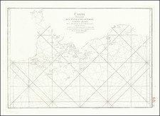
The Only State of the Map Not To Show the Paracel Islands!
Fine example of Aaron Arrowsmith's rare 4-sheet map of the East Indies, with additions to 1809.
The map shows the coasts of the Philippines, China, Burma, Thailand, Malaysia, Indonesia, Sumatra, Vietnam, Cambodia, the Spice Islands and West Papua. Depth shown by bathymetric soundings.
Title set at upper left sheet, with a graticuled border, grid at one degree intervals, numerous coastal soundings, wind directions, and shoals indicated. The map includes details of the best clipper routes to China at various months of the year, as well as the the routes of various English navigators, including Cook.
This 1809 state includes significant revisions from the original 1800 chart. Perhaps the most unusual, and in modern times, politically interesting change is that in this 1809 state of the map, the Paracel Islands have been completely removed in order to add navigational information off the Coast of Vietnam, but have not yet been added back by Arrowsmith. The islands do not re-appear until the issuance of the 1812 state of the map. As such, this entire Paracel island group is completely missing from the present state of the map.
Some of the more noteworthy revisions include:
Northeast Sheet
- The mapping of the Philippines has been fastly improved
- Extensive navigational information and ship tracks have been added throughout the Philippines.
Northwest Sheet
- The Paracel Islands have been removed from the Vietnamese Coastline and replaced with several sets of sailing directions and ship tracks
- The Coast of Hainan has been completely reworked, with the western and southern coastlines completely changed and topographical features added in the interior
- The southern Coast of Vietnam and Cambodia has been completely revised, Sai-Gon City has been added and the "Japanese River" has been removed.
- The Islands South of Mergui (Myeik) and the coastline of Mynmar north of Myeik and Ayeyarwady Delta have been significantly revised
Southwest Sheet
- The islands south of Malaysia in the Straits of Singapore, extending south Po. Lingen, are significantly updated.
- The northern and western coastline of Sumatra is revised
The map presents an impressive four sheet chart of the navigation routes through the southeast Asian archipelago to China and the Philippines. Arrowsmith was a very inventive and accurate mapmaker. This map may have been commissioned specifically for an Asian trading company and was certainly aimed at English sea captains and companies trading to China and southeast Asia.
The detail on depth soundings, winds, obstructions and general accuracy is a trademark of Arrowsmith's fine work. Arrowsmith moved to London in 1770 and was employed by both Faden and John Cary. In 1790, he set up on his own and made his reputation with his 8 sheet world map on Mercator's projection, 1790. It was not until the end of the 19th century that the Hydrographical office of the Royal Navy sent its surveying ships Sulphur, Samarang, Herald and others to the region that accurate nautical charts became available.
This is one of Arrowsmith scarcer charts. We note one example of the 1824 edition in a dealer catalog (Shapero, 2004, Item 219) and one example of the 1809 edition (Manasek, 1992, Item 25). We also note that Christies offered a copy of the 1812 edition of the chart in their July 15, 2005 Travel Sale (Lot 65).
The Arrowsmiths were a cartographic dynasty which operated from the late-eighteenth century to the mid-nineteenth. The family business was founded by Aaron Arrowsmith (1750-1823), who was renowned for carefully prepared and meticulously updated maps, globes, and charts. He created many maps that covered multiple sheets and which were massive in total size. His spare yet exacting style was recognized around the world and mapmakers from other countries, especially the young country of the United States, sought his maps and charts as exemplars for their own work.
Aaron Arrowsmith was born in County Durham in 1750. He came to London for work around 1770, where he found employment as a surveyor for the city’s mapmakers. By 1790, he had set up his own shop which specialized in general charts. Arrowsmith had five premises in his career, most of which were located on or near Soho Square, a neighborhood the led him to rub shoulders with the likes of Joseph Banks, the naturalist, and Matthew Flinders, the hydrographer.
Through his business ties and employment at the Hydrographic Office, Arrowsmith made other important relationships with Alexander Dalrymple, the Hudson’s Bay Company, and others entities. In 1810 he became Hydrographer to the Prince of Wales and, in 1820, Hydrographer to the King.
Aaron Arrowsmith died in 1823, whereby the business and title of Hydrographer to the King passed to his sons, Aaron and Samuel, and, later, his nephew, John. Aaron Jr. (1802-1854) was a founder member of the Royal Geographical Society (RGS) and left the family business in 1832; instead, he enrolled at Oxford to study to become a minister. Samuel (1805-1839) joined Aaron as a partner in the business and they traded together until Aaron left for the ministry. Samuel died at age 34 in 1839; his brother presided over his funeral. The remaining stock and copper plates were bought at auction by John Arrowsmith, their cousin.
John (1790-1873) operated his own independent business after his uncle, Aaron Arrowsmith Sr., died. After 1839, John moved into the Soho premises of his uncle and cousins. John enjoyed considerable recognition in the geography and exploration community. Like Aaron Jr., John was a founder member of the RGS and would serve as its unofficial cartographer for 43 years. Several geographical features in Australia and Canada are named after him. He carried the title Hydrographer to Queen Victoria. He died in 1873 and the majority of his stock was eventually bought by Edward Stanford, who co-founded Stanford’s map shop, which is still open in Covent Garden, London today.
![[Southeast Asia, Philippines & India] Nova Delineatio particularis Apostolicarum Peregrinationum noni Indiarum Apostoli in India Orientali](https://storage.googleapis.com/raremaps/img/small/51679.jpg)
