|
||

|

|
|

|
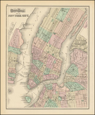
Very scarce later edition of the Mangin-Goerck map of lower Manhattan, one of the most famous and important maps in the history of New York City.
The present map, in its well-preserved original condition, is a handsome object, and it is the only way in which a collector might reasonably hope to obtain a separately-issued 19th-century example of the Mangin-Goerck plan.
This edition, with the bookseller's name at the lower left, was probably issued in the last quarter of the 19th century. It was published by R. D. Cooke, the famous antiquarian map seller of lower Manhattan, and printed by the Leggo Bros.
Another edition, in a similar format, was issued in D. T. Valentine's Manual. We have found examples of the Cooke edition in the Museum of the City of New York.
The Original Mangin-Goerck Map
Commissioned by the City of New York to serve as the first Official Map of the City after the American Revolution, the project was essentially hijacked by Mangin, a highly skilled French surveyor who was in New York fleeing the French Revolution, who determined that he would, in essence, exercise the liberty to create his own image of a master planned expansion of Manhattan, without the permission or shared vision of the Common Council.
The Commissioners, shocked by Mangin's breach of protocol, initially suppressed the map and attempted to retrieve all the printed examples, before allowing the map to be issued in very limited quantities, sold with a disclaimer regarding Mangin's "creative license." There are those who opine that it was, in fact, a change in the power structure of New York's politics that was the real reason for the map's suppression, as the next official survey, the so-called "Commissioner's Plan", would wind up adopting much of Mangin's urban planning.
History of The Original Map
The Mangin-Goerck was the first official plan of the city produced after the Revolution and is one of the rarest and most fascinating of all printed plans of New York. The extraordinary growth of New York meant that most existing maps of the city quickly became obsolete.
In December of 1797, the Common Council of the City of New York contracted the two surveyors, Joseph Francois Mangin and Casimir Goerck, to compile a new map of the city for official use. The price to the city was $3,000 with the stipulation map being offered to subscribers for $4 each was to be split between Mangin and Goerck and the City. The two quickly started work, "During the spring and summer of 1798 they ranged all over the city and beyond, surveying by day, computing and drafting by night" (Koppell). During the summer of 1798, Casimir Goerck succumbed to yellow fever which was ravaging the city at the time. Mangin continued on alone and, in April 1799, presented his manuscript to the Common Council.
In July 1799, Peter Maverick was engaged to engrave the map. Because of the size and complex nature of the map, it took four years to complete.
While drawing the map Mangin had taken the liberty of making his own plans for the city's future, by laying out a grid pattern to the north of the existing streets and smoothing out the shoreline. In this respect, he understood that the city needed a plan for expansion. The Council members apparently knew to some extent of his intentions and offered no objections.
When the engraving was finally completed in 1803, it again was given to the Common Council. Between 1799 and 1803, a political change occurred within the Council. Out went Hamilton's Federalists and in came Jefferson & Burr's Republicans. When Mangin re-submitted the engraved version of his oddly shaped map to the new Commissioners, they declared that it contained "an arrangement certainly to be desired but unfortunately it deviates so much from [previous maps] that the adoption of it would create great difficulties from its total derangement of a great number of lots."
While visionary in its depiction of the City's future, the Common Council rejected the map, directing that the copies of the subscribers be destroyed. The city minutes note
Map of the City lately printed…contains many inaccuracies and designated streets which have not been agreed to by the Corporation [meaning the city] and which it should be improper to adopt, and which might tend to lead the proprietors of the Land adjacent to such streets so laid into error.
The decision was made to suppress the Mangin-Goerck plan, a decision led by the new street commissioner Joseph Browne, brother in law of Aaron Burr. In his book on the history of New York, Gerald Koppell strongly suggests that the suppression of the map was an example of political cronyism championed by Burr and his supporters. Browne turned the entire council against that map resolving "to return the money paid by each subscriber [and] endeavor to recall as many of said maps as have been sold." This act of suppression accounts for the Mangin-Goerck Plan's extreme rarity. A few subscribers did receive their copies after a qualifying label was affixed to the surface of the map warning that the northern two-thirds of the map was invalid.
As of 1928, Stokes had located just six copies of the original Mangin-Goerck. By the time Cohen and Augustyn published Manhattan in Maps in 2006, they noted that "only about ten examples have survived." We previously offered an original example for sale in 2015.
Richard D. Cooke
Richard D. "R. D." Cooke (1829-1912) was a rare map and book dealer based in lower Manhattan working at the end of the 19th century. He was himself trained as a surveyor. Cooke was employed by John Bute Holmes in 1850s, as a surveyor, and they seemed to have shared the same love of old maps of New York City. Indeed Holmes's maps and Cooke's maps are remarkably similar, although Cooke's postdate Holmes's by a few decades. See+our+John+Bute+Holmes+maps+here.
In 1885, Cooke purchased the map collection of Joseph Bridges, who had, in the first half of the 19th century, served as New York City Surveyor. According to contemporary accounts, after Bridges's death, his collection had languished in a cellar, unattended to by his heirs, until Cooke acquired it. He then produced a limited number of copies of some of the better maps from the collection. An 1899 account in the Real Estate Record and Builders' Guide, tells the fascinating story of Cooke's acquisition of the Bridges collection:
It is learned that the Board of Estimate and Apportionment will be asked next week to make an appropriation of $30,000 with which to purchase for the Register's Office the Bridges collection of maps and surveys. The request is to be made in the form of a petition, signed by real estate lawyers, and will be the second petition on the subject presented to the city authorities, the first having been submitted many years ago, shortly after the collection came Into the possession of its present owner. The collection consists of over 5,000 maps, surveys and field books, and contains a very great number of surveys that are not on file in the Register's Office or in other city departments, and of which no duplicates exist, although copies of many of them were originally deposited in various city departments. The comprehensiveness of the collection may be Inferred from the fact that the "Descriptive Index of the Maps on Record In the Office of the Register of the City and County of New York," published by Adolf Dengler in 1875, comprises less than 1,500 titles.
The founder of the collection was William Bridges, city surveyor in New York, who died about 1812, leaving two sons, BJ. W. and Joseph F. to continue his business, as partners. Joseph F., who survived his brother, died in the seventies. William Bridges was one of the surveyors employed by the Commission of 1807 to lay out the City Plan, and is reputed to have been the author of the commission's report of 1811. In that year he published a book, now extremely rare, entitled "Map of the City of New York and Island of Manhattan, with Explanatory Remarks and References," on the title page of which he styles himself architect and city surveyor. His sons, in their day, had a very extensive practice, and, as the collection shows, were frequently employed by the city to make surveys for street openings and public improvements. The father and sons naturally retained copies of their public as well as private surveys, which, with their field books, extended over a period of about three-quarters of a century. To this original collection they added copies of Important and scarce surveys made by others. As the collection exists to-day there is hardly an inch of ground south of 14th street which it does not cover, besides containing numerous surveys north of that line, including some in the Annexed District. When Joseph F. Bridges retired from active life, as he had no successor in business the collection was removed to his residence in Brooklyn, where he continued to give consultations. Before his death he disposed of part of the collection, which part appears to have consisted of Brooklyn maps, in payment of some claims. After his death several maps are known to have been surreptitiously sold by a degenerate son. On the foreclosure of a mortgage on the family home the collection was removed to a cellar, whence it was rescued when purchased in 1885 by R. D. Cooke, a dealer in scarce books and maps.
Mr. Cooke's first intention was to sell the maps singly, as opportunity afforded, and did sell half a dozen, one of which, a map of Broadway, between the Battery and Canal street, is now in the New York Historical Society Library. Later, at the instance of real estate lawyers who wished to see the collection acquired by the city, he determined to keep it together, and has since sold only tracings-Mr. Cooke was himself educated for the profession of a surveyor. About a dozen of the larger maps, mostly partition maps of old farms, have been published in limited editions, none of which sell for less than $10 a copy. The value of the collection is recognized not only by title searchers but also by writers, and no historian of New York can afford to overlook it. It is referred to in the following acknowledgment by Thomas A. Janvier in his book "In Old New York:" "In determining the lines of old roads, and the boundaries of old estates, I have had the assistance of Mr. Richard D. Cooke, the highest authority in such matters in New York, and the use of his unique collection of maps." Instances are common of universities importing libraries of foreign scholars at a cost equaling the price demanded for the Bridges collection, although such libraries have a scientific value only. The Bridges collection Is of the very first scientific value, for apart from books and manuscripts, it is the most important sourse [sic] in existence for the history of New York City during three-quarters of a century. Besides, it has an extremely practical bearing on practical interests, for should the information which It contains regarding old boundaries and surveys be lost a cloud would be thrown upon many titles to real estate, especially in the lower part of the city.
Cooke was eulogized in The Publisher's Weekly:
RICHARD D. COOKE, known to old New Yorkers for his famous bookshop near the place where the Criminal Courts Building now stands, died, on June 7, at the home of his daughter, Mrs. John H. Nimon, at 4 Hawthorne Avenue, Jersey City. Cooke's bookshop was a favorite browsing ground for historians, for these Mr. Cooke had at one time the most nearly complete set of maps of the old city and volume upon volume telling of the beginnings of Manhattan.
Thomas A. Janvier, in his introduction to his book, "Old New York," says: "I have had the assistance of Richard D. Cooke and his collection of old New York maps. He is the highest authority in such matters in New York."
The man who won such high praise came from Tipperary, Ireland, one of fourteen children. He was born there eighty-three years ago, and came to this country in 1851 to work for John Holmes, a New York surveyor. He did much of the work in laying out the Morris & Essex Railroad, and in Mr. Holmes' office he first got the idea of collecting the maps of the city.
In 1860 he started for himself and opened a bookstore in Liberty Street, later moving up to Centre Street. When the Criminal Courts Building was erected, Mr. Cooke retired and went to live with his daughter, who alone survives him.
Richard D. "R. D." Cooke (1829-1912) was a rare map and book dealer based in lower Manhattan working at the end of the 19th century. He was himself trained as a surveyor. Cooke was employed by John Bute Holmes in 1850s, as a surveyor, and they seemed to have shared the same love of old maps of New York City. Indeed Holmes's maps and Cooke's maps are remarkably similar, although Cooke's postdate Holmes's by a few decades. See+our+John+Bute+Holmes+maps+here.
In 1885, Cooke purchased the map collection of Joseph Bridges, who had, in the first half of the 19th century, served as New York City Surveyor. According to contemporary accounts, after Bridges's death, his collection had languished in a cellar, unattended to by his heirs, until Cooke acquired it. He then produced a limited number of copies of some of the better maps from the collection. An 1899 account in the Real Estate Record and Builders' Guide tells the fascinating story of Cooke's acquisition of the Bridges collection:
It is learned that the Board of Estimate and Apportionment will be asked next week to make an appropriation of $30,000 with which to purchase for the Register's Office the Bridges collection of maps and surveys. The request is to be made in the form of a petition, signed by real estate lawyers, and will be the second petition on the subject presented to the city authorities, the first having been submitted many years ago, shortly after the collection came Into the possession of its present owner. The collection consists of over 5,000 maps, surveys and field books, and contains a very great number of surveys that are not on file in the Register's Office or in other city departments, and of which no duplicates exist, although copies of many of them were originally deposited in various city departments. The comprehensiveness of the collection may be Inferred from the fact that the "Descriptive Index of the Maps on Record In the Office of the Register of the City and County of New York," published by Adolf Dengler in 1875, comprises less than 1,500 titles.
The founder of the collection was William Bridges, city surveyor in New York, who died about 1812, leaving two sons, BJ. W. and Joseph F. to continue his business, as partners. Joseph F., who survived his brother, died in the seventies. William Bridges was one of the surveyors employed by the Commission of 1807 to lay out the City Plan, and is reputed to have been the author of the commission's report of 1811. In that year he published a book, now extremely rare, entitled "Map of the City of New York and Island of Manhattan, with Explanatory Remarks and References," on the title page of which he styles himself architect and city surveyor. His sons, in their day, had a very extensive practice, and, as the collection shows, were frequently employed by the city to make surveys for street openings and public improvements. The father and sons naturally retained copies of their public as well as private surveys, which, with their field books, extended over a period of about three-quarters of a century. To this original collection they added copies of Important and scarce surveys made by others. As the collection exists to-day there is hardly an inch of ground south of 14th street which it does not cover, besides containing numerous surveys north of that line, including some in the Annexed District. When Joseph F. Bridges retired from active life, as he had no successor in business the collection was removed to his residence in Brooklyn, where he continued to give consultations. Before his death he disposed of part of the collection, which part appears to have consisted of Brooklyn maps, in payment of some claims. After his death several maps are known to have been surreptitiously sold by a degenerate son. On the foreclosure of a mortgage on the family home the collection was removed to a cellar, whence it was rescued when purchased in 1885 by R. D. Cooke, a dealer in scarce books and maps.
Mr. Cooke's first intention was to sell the maps singly, as opportunity afforded, and did sell half a dozen, one of which, a map of Broadway, between the Battery and Canal street, is now in the New York Historical Society Library. Later, at the instance of real estate lawyers who wished to see the collection acquired by the city, he determined to keep it together, and has since sold only tracings-Mr. Cooke was himself educated for the profession of a surveyor. About a dozen of the larger maps, mostly partition maps of old farms, have been published in limited editions, none of which sell for less than $10 a copy. The value of the collection is recognized not only by title searchers but also by writers, and no historian of New York can afford to overlook it. It is referred to in the following acknowledgment by Thomas A. Janvier in his book "In Old New York:" "In determining the lines of old roads, and the boundaries of old estates, I have had the assistance of Mr. Richard D. Cooke, the highest authority in such matters in New York, and the use of his unique collection of maps." Instances are common of universities importing libraries of foreign scholars at a cost equaling the price demanded for the Bridges collection, although such libraries have a scientific value only. The Bridges collection Is of the very first scientific value, for apart from books and manuscripts, it is the most important sourse [sic] in existence for the history of New York City during three-quarters of a century. Besides, it has an extremely practical bearing on practical interests, for should the information which It contains regarding old boundaries and surveys be lost a cloud would be thrown upon many titles to real estate, especially in the lower part of the city.
Cooke was eulogized in The Publisher's Weekly:
RICHARD D. COOKE, known to old New Yorkers for his famous bookshop near the place where the Criminal Courts Building now stands, died, on June 7, at the home of his daughter, Mrs. John H. Nimon, at 4 Hawthorne Avenue, Jersey City. Cooke's bookshop was a favorite browsing ground for historians, for these Mr. Cooke had at one time the most nearly complete set of maps of the old city and volume upon volume telling of the beginnings of Manhattan.
Thomas A. Janvier, in his introduction to his book, "Old New York," says: "I have had the assistance of Richard D. Cooke and his collection of old New York maps. He is the highest authority in such matters in New York."
The man who won such high praise came from Tipperary, Ireland, one of fourteen children. He was born there eighty-three years ago, and came to this country in 1851 to work for John Holmes, a New York surveyor. He did much of the work in laying out the Morris & Essex Railroad, and in Mr. Holmes' office he first got the idea of collecting the maps of the city.
In 1860 he started for himself and opened a bookstore in Liberty Street, later moving up to Centre Street. When the Criminal Courts Building was erected, Mr. Cooke retired and went to live with his daughter, who alone survives him.
![[Harlem]. Map of the Harlaem Commons surveyed agreeably to the boundaries established by the Commissioners appointed to settle the boundary lines between the common lands of the City of New York and the Town of Harlaem...](https://storage.googleapis.com/raremaps/img/small/59385.jpg)
![[Manhattan / Lower East Side]](https://storage.googleapis.com/raremaps/img/small/59559.jpg)