|
||

|

|
|

|
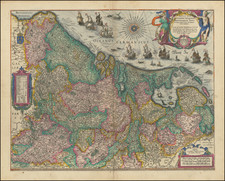
A Rare Carte-a-figures Map of the 17 Provinces -- Apparently Unknown To Van Der Heijden
Striking example of Frederick De Wit's map of the 17 Provinces, published in 1659.
The map includes the coat of arms of each of the 17 provinces, along with 19 city views.
The map was originally engraved and published by P. Kaerius in 1607. Van der Heijden notes that in 1662, the plate came in the possession of Frederick de Wit, who re-engraved the cartouche of the map. He added two large vessels between the title cartouche and compass-rose.
A later state was issued by Theunisz Jacobsz, where the upper right corner of the plate is beginning to crack.
We note a single example of the map, lacking the City Views, in the collection of the National Library of France: https://www.rechercheisidore.fr/search/resource/?uri=ark:/12148/btv1b8469529q
De Wit (1629 ca.-1706) was a mapmaker and mapseller who was born in Gouda but who worked and died in Amsterdam. He moved to the city in 1648, where he opened a printing operation under the name of The Three Crabs; later, he changed the name of his shop to The White Chart. From the 1660s onward, he published atlases with a variety of maps; he is best known for these atlases and his Dutch town maps. After Frederik’s death in 1706, his wife Maria ran the shop for four years before selling it. Their son, Franciscus, was a stockfish merchant and had no interest in the map shop. At the auction to liquidate the de Wit stock, most of the plates went to Pieter Mortier, whose firm eventually became Covens & Mortier, one of the biggest cartography houses of the eighteenth century.
![[Proposed Canal / Utrecht to the Sea] Nieuwe en Nette Aftekening van de Door Gravinge die er staat te Geschieden beginnende van de Stadt Utrecht to aan Spakenborg in de Zuyder Zee met des zelfs Afbakinge &c](https://storage.googleapis.com/raremaps/img/small/94380.jpg)
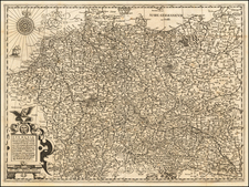
![[ Holy Roman Empire ] Nova Totius Germaniae Descriptio Geographica](https://storage.googleapis.com/raremaps/img/small/95672.jpg)